
In this article, I will discuss the rivers of Bihar, their origin, drainage basin, and catchment areas of the rivers of Bihar. Also, the other important topics related to it which are important for both the exam and general purpose.
To read the geography of Bihar, Kindly click the link below.
Geography4u/geography of bihar
Table of Contents
Introduction
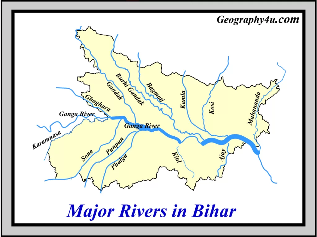
Being an agriculture dominant state, rivers play a vital role in the economy of Bihar. Bihar is endowed with a number of perennial and seasonal rivers. These rivers form the basis for surface water in Bihar. Both the northern and some parts of southern alluvial tracts of Bihar have water available throughout the year. The Ganga river divides Bihar into two unequal parts. Therefore, the rivers of Bihar have been classified under two major categories i.e. river of North and South Bihar.
Rivers in north Bihar
In Bihar, the north of the Ganga river lies the alluvial plains namely the north Bihar plains. These plains are endowed with a number of rivers which are both perennial and seasonal in nature. Most importantly, some of the rivers of north Bihar are Ghaghra, Gandak, Burhi Gandak, Kosi and Mahananda etc. These rivers fall into the Ganga river. On the other hand, Bagmati-Adhwara, Kamla-Balan etc. fall into the Ganga river through the Kosi river.
| Sr. No. | Northern Rivers |
| 1. | Ghaghra |
| 2. | Gandak |
| 3. | Burhi-Gandak |
| 4. | Bagmati |
| 5. | Kamla |
| 6. | Kosi |
| 7. | Mahananda |
Characteristics of Rivers of North Bihar
- Geographically, the major rivers of northern Bihar have Himalayan Origin.
- Also, a considerable portion of their catchment lies in the glacial region.
- Due to their Himalayan origin, these rivers lie between Nepal and Tibet.
- During the monsoon season, these rivers receive an abundant amount of precipitation which is 80 to 90 times larger than the fair weather.
- Some of the rivers of this region namely Gandak, Burhi Gandak and Ghagra are more or less stable.
- In the process of shifting course, these rivers also form chaurs (Ox-bow lakes).
- On the other hand, the other rivers of northern Bihar namely Baghmati, Adhawra groups, Kamla-Balan and Kosi are still very unstable.
- Due to high siltation and steep slopes in their upper reaches, these rivers cause a huge amount of disasters.
Rivers in South Bihar
The tract of the south Bihar is drained mainly by the rivers namely Karmnasa, Sone, Punpun, Kiul, Badua Chandan etc. all falling into the Ganga.
Characteristics of rivers of the South Bihar
- The rivers of southern Bihar have their origin either in the Vindhyanchal hills or in the hills of Chhotanagpur and Rajmahal.
- The southern bank of the Ganga is formed as a leeve, obstructing the drainage of the land.
- Also, the southern plains of Bihar are marked by the Tal formation (a low-lying area) due to the course of several rivers.
Important tals of Southern Bihar
- Fatuha Tal.
- Bakhtiyarpur Tal.
- Barh Tal.
- More Tal.
- Mokama Tal.
- Barahiya Tal.
- Singhaul Tal.
These tals receive backwater of the Ganga river when it is in high spate. During Monsoon season, these tals get submerged in water. Thus, they are deprived of the cultivation of the Kharif crop. The soils of tal areas and their vicinity are medium to heavy textured and slightly to moderately alkaline.
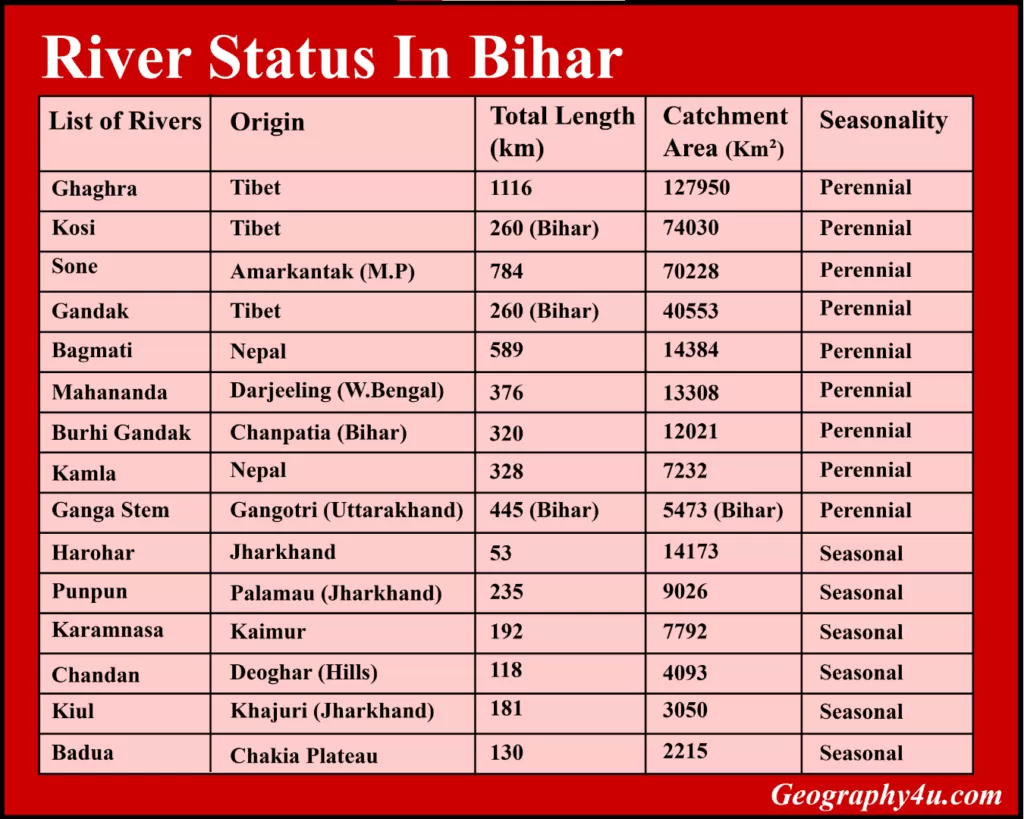
River Status of Bihar
Click here to download the complete economic survey of Bihar in Pdf.
Drainage basin of Bihar
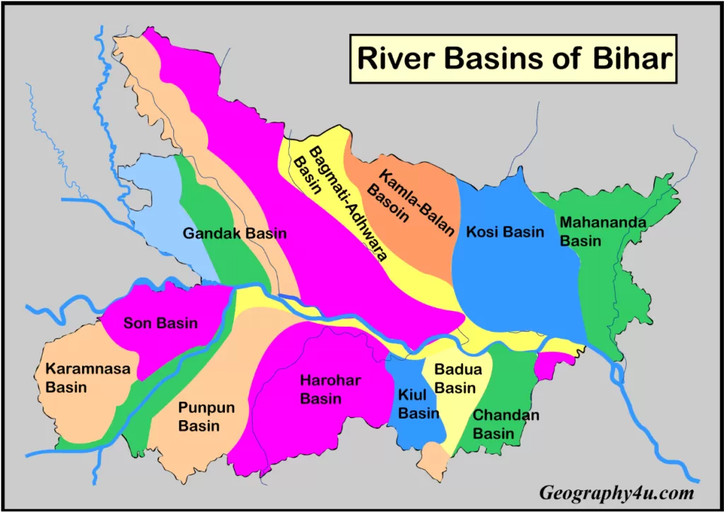
In Bihar, the Ganga river has a total length of 445km. Also, it has a catchment area of 5473km2. In terms of the catchment area, the other three major rivers are Kosi (74,030km2), Sone (70,228 km2) and Gandak river (40553 km2). The catchment area of the other rivers has been discussed in the following table.

Problem of water-logging in Bihar
Geographically, about 10% of the area of Bihar is water-logged. In terms of area, 8.32 lakh hectare in North Bihar and 1.09 lakh hectare in south Bihar is water-logged. The spilling of silts caused by small rivers, the encroachment of drainage channels, ox-bow lakes and embarkment induced water-logging are the main reasons for water-logging in Bihar.

Water potential of Bihar
As per the estimate, the average basin-wise potential of water was highest in the Gandak Baya river basin (47350MCM) followed by the Kosi river basin (41615MCM). On the other hand, the lowest water potential was observed in the Kiul river basin, accounts for (710MCM).
Quality of River water of Bihar
Despite having 15 river basins in Bihar, there has been a growing concern over the quality of river water due to depletion of groundwater levels. Due to the growing population and demands of water (for irrigation, industries, domestic consumption and other purposes) the water level have reducing day-by-day. Under the national water quality monitoring programme, the central pollution control board monitors the quality of river water in India. The quality of water is measured in terms of PH level, Bio-chemical oxygen demand (B.O.D), conductivity, amount of faecal and total coliform. In Bihar, the organic pollution is measured in B.O.D count was less than 3mg/l.
Frequently Asked Questions
Which is the longest river in Bihar?
Ganga river (445km) followed by the Bagmati river (394km).
Name the river, commonly known as Sorrow of Bihar?
The Kosi river is known as the sorrow of Bihar.
Which river divides Bihar into two parts?
Ganga river divides Bihar into two unequal parts.
The other name of Ghaghra river is?
The Ghaghra river is commonly known as Saryu river in Bihar.
Name the river of Bihar which is sacred for both Hindu and Buddhist?
The Phalgu/Falgu river is sacred for both Hindus and Buddhists.
- How did the theory of plate tectonics evolve over time?
- 7 Criticisms of Continental Drift Theory by Alfred Wegener
- Malthus theory of population: critical analysis & relevance
- Major Types of Clouds formation and their Characteristics
- Get Detailed Bpsc syllabus 2022-23
- Complete bpsc geography optional syllabus 2022
Pingback: Detailed Bpsc syllabus 2022-23 | Geography4u.com