
In this article, I will discuss the important agro-climatic zones in India with the help of maps. Agriculture plays a vital role in the overall economy of India. According to the 2011 census of India, about 54.6% of the population is engaged in agriculture and allied activities. Also, agriculture contributes about 17.4% of the gross value added (GVA) for the year 2016-17 (at current price) in India. However, the large areal extent of India gives rise to regional and intra-regional disparities. The government of India has demarcated various agro-climatic zones in India to neutralize disparities among the various regions.
Table of Contents
Agro-climatic zones in India
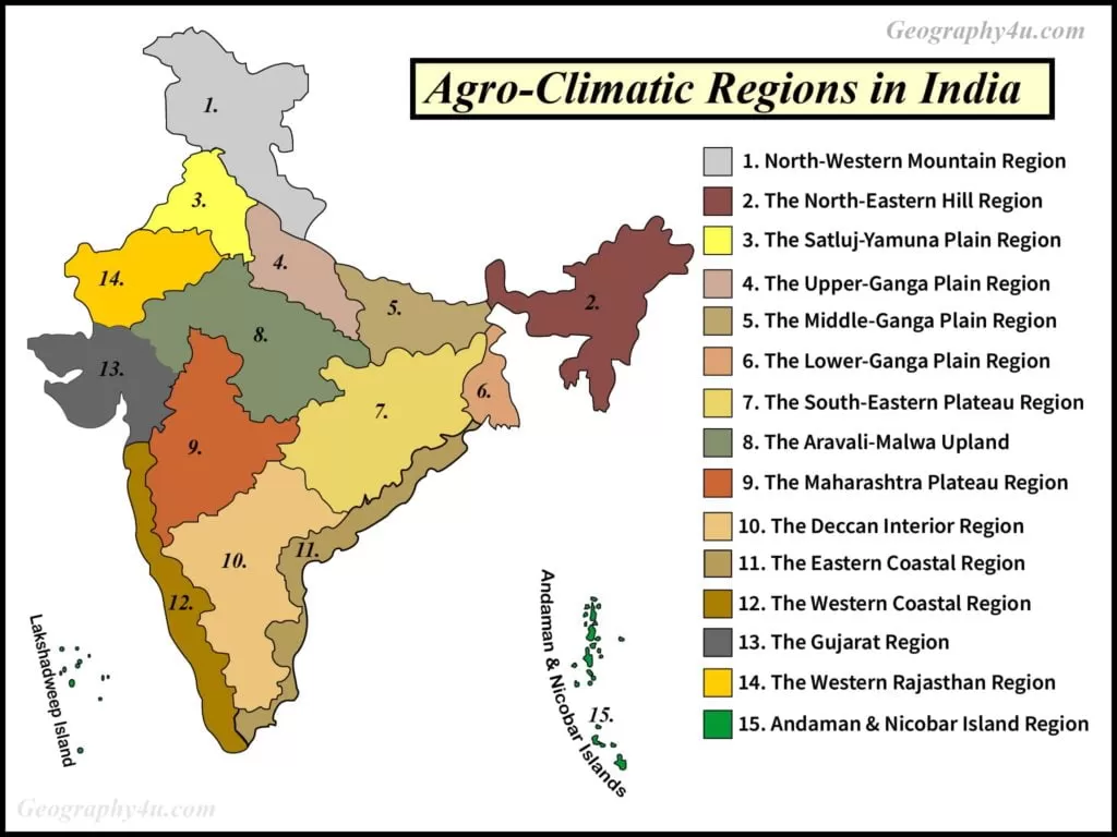
According to the Planning Commission of India, there are 15 agro-climatic zones in India. These agro-climatic regions are delineated on the bases of agro-climatic features. For instance, soil type, temperature, topography, cropping and farming system and water resources. The following are the important agro-climatic zones of India.
- The North-Western Mountainous region.
- The North-East region.
- The Sutlej-Yamuna Plains region.
- The Upper Ganga Plains region.
- The Middle Ganga Plains region.
- The Lower Ganga Plains region.
- The South-Eastern Plateau.
- The Aravali-Malwa upland region.
- The Plateau of Maharashtra region.
- The Deccan interior region.
- The Eastern Coastal region.
- The Western Coastal region.
- The Gujarat region.
- The Western Rajasthan region.
- The Islands of Andaman and Nicobar.
North-Western Mountainous region
- The northern-western mountainous agro-climatic region consists of Jammu and Kashmir (J&K), Himachal Pradesh and Uttarakhand.
- This region is covered by mountain peaks, steep slopes, Himalayan rivers, evergreen forests and deciduous forests.
- Climatologically, the summer and winters in this region are mild and severe respectively.
- Geographically, the agricultural activities in this region are confined to the mountain valleys, rivers terraces and gentle slopes.
- The hilly areas are dominated by maize while the floors of the valley are dominated by rice.
- Also, this agro-climatic zone is well-known for the cultivation of orchards. For instance, the apple orchards of J&K, Uttarakhand and Himachal Pradesh.
- The local tribes namely, Gujjars, Bakarwal and Gaddis extensively use the alpine pastures for the rearing of sheep, goats, cattle and horses.
- Geographically, this region is prone to landslide, soil erosion and earthquake.
- Poor accessibility, inadequate marketing and storage facilities and poor weather are the major problems of this region.

Read more: Himalayas, the great mountain system
Read the complete article on the mountain Himalaya at the above link.
The North-Eastern Region
- The north-eastern region spreads over the seven states of India, namely, Arunachal Pradesh, Assam, Manipur, Meghalaya, Mizoram, Nagaland and Tripura.
- Also, this agro-climatic region is divided further into two subdivisions namely, The Brahmaputra Valley and The Hilly states.
- This region is marked by both the high rainfall and relative humidity with mild temperature.
- The local tribes and forests dwellers in this zone usually practice Shifting Cultivation.
- Rice is the major crop in the plains while tee plantation is the major cash crop of this region.
- Also, it has a combination of soils, vary from different altitude.
- The world’s most annual rainfall region also falls in this zone.
- Moreover, the world’s largest river island, Majuli situated in this region.
The Satluj-Yamuna Plain region
- The majority of this region lies in the two states namely, Punjab and Haryana.
- The annual temperature range is high due to great continentality.
- The average annual rainfall ranges between 50cm-60cm.
- Due to western disturbances, this region also receives rainfall in winter.
- Climatologically, May is the hottest month while January is the coldest month of this agro-climatic zone.
- This region is well-equipped with canals, pumps and tube wells which help in the extensive irrigation of crops.
- The major crops of this region are rice, sugarcane, cotton and fodder, wheat, peas, grams and oilseeds.
- Agriculturally, it is one of the most developed regions of India.
- However, this region faces the problems of salinization, soil erosion and water-logging.
The Upper Ganga plain region
- The upper Ganga plain is located in Uttar Pradesh mainly over the greater parts of Ganga-Yamuna doab, Rohilkhand and Awadh plains.
- This region is drained by the Ganga river and its tributaries.
- During summer, this region experiences the dust storms.
- Geologically, it is covered by the sediments and alluvial soil eroded by the perennial rivers of Himalayan origin.
- The average annual rainfall varies between 65cm to 120cm.
- The upper Ganga plain region receives about 80% of annual rainfall during the summer.
- Also, it is well equipped with tube wells and pumps.
- Canals and underground water are the major sources of irrigation of this region.
- The major crops of this region are rice, maize, sugarcane, wheat, pulses and potatoes.
- In terms of horticulture, it has orchards of mango, guava, peaches and litchi.
- Like Satluj-Yamuna plains, this region also faces the problem of alkalinity and salinity of the soil.
Middle Ganga plain region
- This region stretches over the eastern Uttar Pradesh and the greater parts of Bihar.
- The Middle Ganga plains are marked by hot and humid summer and mild winter.
- The mean maximum temperature in summer is about 4⁰C while the mean minimum temperature in winter is about 5⁰C.
- This region receives most of the rainfall from the south-west monsoon originated in the Bay of Bengal.
- The average rainfall is about 100cm to 150cm.
- Geographically, the majority of this region is covered by fertile alluvial soil.
- Agriculturally, rice, wheat, pulses, sugarcane and oilseeds are the major crops of this region.
- However, about 24% of the flood-affected area lies in this region (mainly in Bihar).
- Due to high marginal farmers and small landholding, the modern techniques of farming are not practised in this agro-climatic region.
- Also, Bihar faces the problems of both floods and drought simultaneously which reduce the overall productivity of farmers.

The Lower-Ganga plain region
- Geographically, this region lies in the lower portion of West Bengal.
- Due to predominance of floods, this region is covered with fine clayey to silty-clay of soils.
- Climatologically, it has a hot and humid climate.
- The mean minimum temperature is about 15⁰C.
- Agriculturally, the Lower-Ganga plain is suitable for the cultivation of rice and jute plantation.
- Being a coastal region, it enjoys the benefits of Pisciculture and its allied sector.
- Due to the occurrence of natural disasters like cyclones and floods, the farmers of this zone are very poor.
The Aravali-Malwa Plateau region
- The Aravali-Malwa plateau region spreads over the western Madhya Pradesh and the eastern parts of Rajasthan.
- Geologically, the southwestern part of this region has black soil.
- The average annual rainfall of this zone ranges between 50cm to 100cm.
- Cotton, soybean, millets, maize and pulses are the major crops of this region.
- Due to lack of irrigational facilities, the agriculture of this region is dependent on the south-west monsoon of India.
- Also, this region is marked by residual mountain hills and hard rocks.
Maharashtra Plateau region
- The plateau of Maharashtra spreads over the Maharashtra and western Madhya Pradesh.
- It has rich black soil which is suitable for cotton cultivation.
- Being a rain-shadow region, it faces the problem of drought.
- The major crops of this region are cotton, pulses, oilseeds, wheat, grams and millets.
- Due to limited irrigational facilities, millet is the staple crop of this region.
The Interior Deccan region
- This region lies in the three states namely, Karnataka, Andhra Pradesh and Tamil Nadu.
- Like the Maharashtra Plateau region, it is also a drought-prone area due to high variability of rainfall pattern.
- Geologically, it has red and yellow soil.
- The major crops of this region are millet, ragi, rice, cotton, groundnuts and pulses.
The Eastern Coastal region
- This region lies between the districts of Balasore and the Kanyakumari.
- The eastern coastal agro-climatic region is covered with the rich alluvial soil deposited by the rivers namely, Mahanadi, Godavari, Krishna and Kaveri.
- The annual rainfall of this region varies between 100cm to 120cm.
- Rice and Jute are the major crops of this region.
- Being a coastal region, it has a huge potential for Pisciculture and Aquaculture.
The Western Coastal regions
- The western coastal agro-climatic region spreads over the three states namely, Maharashtra, Karnataka and Kerala.
- This region receives high rainfall during the southwest monsoon.
- The important crops of this region are rice, coconut, spices and cashew nuts.
The Gujarat region
- The coastal area of Gujarat agro-climate region is humid while the interior parts of this region are dry.
- The average rainfall is about 100cm.
- Geologically, the major parts of this region have black soil.
- The agro-climatic condition of this region is suitable for the cultivation of cash crops like Groundnuts and cotton.
The Western Rajasthan Region
- The western Rajasthan region mainly consists of the deserts namely, the Thar desert of Marwar and the Aravali’s of Mewar.
- Geologically, it has sandy soil which is marked by sand dunes.
- This region is drained by ephemeral rivers like Luni rivers.
- Also, it consists of residual hills and hard rocks.
- Due to inadequate irrigation facilities, the inhabitants of this region practise subsistence farming.
The Indra Region
- The Indra region lies in the states of Rajasthan, particularly in the Ganganagar and Bikaner districts.
- This region is marked by water-logging and salinization.
- It receives the rainfall during the southwest monsoon in India.
The Islands of Andaman and Nicobar region
- Being surrounded by water bodies, this region enjoys the moderating effect of the Indian Ocean.
- This region has tropical climate endowed with tropical rainforests.
- Climatologically, it has moderating temperature with high humidity.
- It receives rainfall in both the southwest monsoon and retreating monsoon.
- Having a tropical climate, this region is suitable for the cultivation of tropical crops.
- The important crops of this agro-climatic region are spices, coconut, rice, maize, oilseeds and pulses.
- It has great potential for both Aquaculture and Silviculture.
- The hot and humid climate provides the breeding ground for the mosquitoes which cause diseases like Malaria and Dengue.

The objectives of Agro-climatic zones of India
- To bring a balance in demand and supply of major commodities.
- Utilizing the full potential of each agro-climatic zones of India.
- To generate employment in India.
- To promote the idea of sustainable utilization of natural resources (land, water and forests).
- To maximize the net income of farmers.
- To provide a framework for economic planning.
FAQ: Agro-climatic zones in India
How many agro-climatic zones are there in India?
After conducting a study on regionalisation, the Planning Commission of India has demarcated 15 agro-climatic zones in India.
Name the Agro-climatic zones in India which receive maximum rainfall?
The North-Eastern Hill agro-climatic region receives maximum rainfall.
- Aurora Borealis 2026: The Science, The Solar Maximum, and Where to See the Northern Lights This Year
- How did the theory of plate tectonics evolve over time?
- 7 Criticisms of Continental Drift Theory by Alfred Wegener
- Malthus theory of population: critical analysis & relevance
- Major Types of Clouds formation and their Characteristics
- Get Detailed Bpsc syllabus 2022-23
- Complete bpsc geography optional syllabus 2022
- Major mineral resources of India with maps
- Von thunen theory of agricultural location