For most people in North America, Europe, or Australia, that number sounds impossible. It isn’t. It’s the monsoon — the largest, most powerful seasonal weather system on Earth. It brings 80 percent of annual rainfall to an area that is home to half the world’s population. It feeds the crops that sustain 1.4 billion people in India alone. And in 2026, it is behaving strangely — arriving weaker than expected, with a developing El Niño threatening to suppress it further through the rest of the year.This is the complete guide to monsoons. What they are, how they work, where they happen, and why the 2026 monsoon season matters far beyond the countries where the rain actually falls.
- What Is a Monsoon? (The Simple Answer)
- The Science: How Monsoons Form
- Step 1: The Land Heats Up
- Step 2: Air Pressure Reverses
- Step 3: The ITCZ Migrates
- Step 4: Moisture Is Delivered
- Step 5: The Coriolis Effect Bends the Winds
- Why the Monsoon Is Not Just “A Lot of Rain”
- The Indian Monsoon: The Largest on Earth
- India Actually Has Two Monsoons
- The Two Branches of the Southwest Monsoon
- The Tibetan Plateau: The Monsoon’s Hidden Amplifier
- The Monsoon’s Withdrawal: September to November
- Western Disturbances: India’s Winter Rain
- Monsoons Around the World
- The North American Monsoon: America’s Own Monsoon
- The West African Monsoon: Life and Death in the Sahel
- The East Asian Monsoon: Plum Rains and Typhoons
- The Australian Monsoon: The Southern Hemisphere’s Wet Season
- Why Some Places Get Meters of Rain and Others Get Almost None
- The Wettest Places on Earth
- The Driest Places in a Monsoon Country
- The Western Ghats: India’s Rainfall Dividing Line
- Monsoon Breaks: When the Rain Stops Mid-Season
- El Niño and the Monsoon: The 2026 Crisis
- How El Niño Suppresses the Monsoon
- The 2026 El Niño: Potentially Record-Setting
- The Indian Ocean Dipole: The Other Variable
- How Climate Change Is Altering the Monsoon
- Why the Monsoon Affects Your Life (Even If You’ve Never Seen One)
- Frequently Asked Questions
- What is a monsoon in simple terms?
- Is a monsoon the same as a hurricane?
- Does the United States have a monsoon?
- How does El Niño affect the monsoon?
- Why does Cherrapunji get so much rain?
- When does the monsoon season start and end?
- Is the monsoon getting stronger because of climate change?
- What is a monsoon break?
- Final Thoughts: The Weather System That Feeds Half the World
What Is a Monsoon? (The Simple Answer)
A monsoon is a seasonal reversal of wind direction that produces a dramatic shift between wet and dry seasons. The word comes from the Arabic mawsim, meaning “season” — ancient Arab sailors used the term to describe the predictable winds that carried their trading ships across the Indian Ocean.Most people associate monsoons with rain. But technically, a monsoon is a wind pattern, not a rainstorm. The rain is the consequence — the most visible and impactful consequence — of the wind reversing direction.
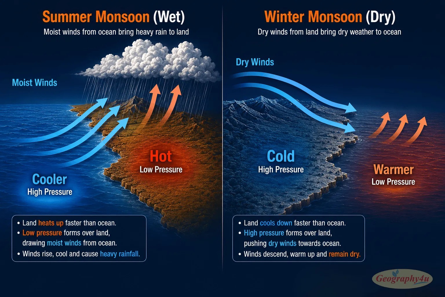
Here is how it works in one paragraph: During summer, land heats up faster than the ocean. Hot air over the land rises, creating low pressure. Cooler, moisture-laden air rushes in from the ocean to fill the gap — and as this ocean air rises over the hot continent, it cools, condenses, and produces enormous amounts of rainfall. In winter, the process reverses: the land cools faster than the ocean, creating high pressure over the continent, and dry winds blow from land toward the sea. Wet season, dry season. Monsoon.This cycle powers the most important weather systems in the tropics and subtropics. Roughly half the world’s population — over 4 billion people — lives in regions directly affected by monsoon systems. Their agriculture, water supply, economies, and daily lives are organized around the monsoon’s predictable rhythm.
The Science: How Monsoons Form
Every monsoon on Earth is driven by the same fundamental principle: differential heating of land and sea. The details vary by region, but the engine is identical everywhere.
Step 1: The Land Heats Up
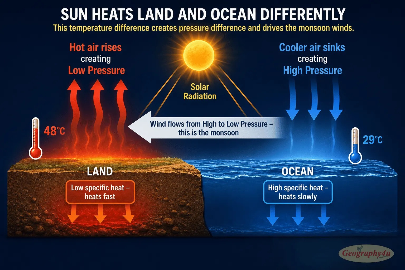
Land and water respond to solar energy differently. Land has a low specific heat capacity — it heats quickly and cools quickly. Water has a high specific heat capacity — it absorbs far more energy before its temperature changes, and it retains that heat longer.During summer, continental interiors heat up dramatically. In India, surface temperatures in the Thar Desert and Indus Valley reach 45-50°C by May and June. Meanwhile, the Indian Ocean surface stays at a relatively mild 28-30°C. This creates a temperature difference of 15-20°C between the land and the adjacent ocean — an enormous thermal gradient.
Step 2: Air Pressure Reverses
As the land heats, the air above it warms, expands, and rises. This creates a region of low atmospheric pressure over the continent. Over the cooler ocean, the air is denser and sinks, creating high atmospheric pressure. Wind always flows from high pressure to low pressure — so moisture-laden ocean air is pulled toward the continent.
Step 3: The ITCZ Migrates
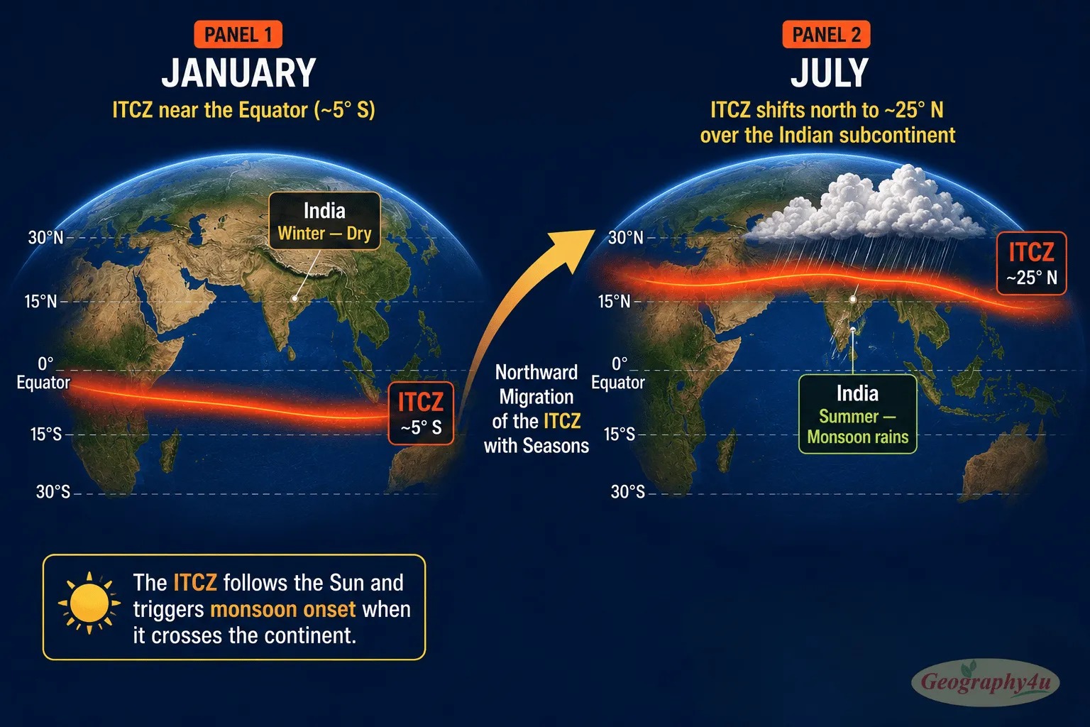
The Inter-Tropical Convergence Zone (ITCZ) — the belt of maximum solar heating near the equator where trade winds from the Northern and Southern Hemispheres converge — does not stay fixed. It migrates north in the Northern Hemisphere summer and south in the Southern Hemisphere summer, following the position of maximum solar heating.When the ITCZ moves over a continent, it brings with it intense convergence of moisture-laden air. In the case of the Indian monsoon, the ITCZ moves from its winter position near the equator to about 25°N by July — well into the Indian subcontinent. This northward migration of the ITCZ is one of the key triggers for monsoon onset.
Step 4: Moisture Is Delivered
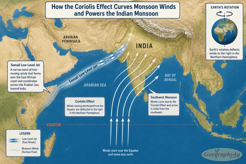
The monsoon winds carry enormous quantities of moisture from the warm tropical ocean. As this moisture-laden air travels inland and rises — either due to convection (hot air rising), convergence (air masses meeting), or orography (hitting mountains) — it cools. Cooler air cannot hold as much moisture, so the water vapor condenses into clouds and precipitates as rain. Often, very heavy rain.The scale of moisture transport is staggering. During the peak of the Indian monsoon, the atmosphere over India contains approximately 20 times more moisture than during the dry season. The Somali Low-Level Jet — a narrow ribbon of fast-moving wind at about 1.5 km altitude that flows from East Africa across the Arabian Sea — acts as a “moisture superhighway,” delivering water vapor to India at speeds of up to 80 km/h.
Step 5: The Coriolis Effect Bends the Winds
If Earth did not rotate, monsoon winds would blow in a straight line from the ocean to the continent. But Earth does rotate, and the Coriolis Effect deflects moving air — to the right in the Northern Hemisphere, to the left in the Southern Hemisphere. This deflection is why the Indian monsoon winds do not arrive from due south. Instead, they curve: the winds that originate near the equator arrive in India from the southwest — hence the name “Southwest Monsoon.”The Coriolis Effect also helps explain why the Somali Low-Level Jet is so concentrated and fast. As equatorial air accelerates northward from East Africa, the Coriolis deflection compresses the airflow into a narrow jet stream, intensifying its speed and moisture-carrying capacity.
Why the Monsoon Is Not Just “A Lot of Rain”
The crucial distinction between a monsoon and ordinary heavy rainfall is scale and persistence. A thunderstorm delivers rain for minutes to hours over a small area. A monsoon delivers rain for weeks to months across an entire continent. The atmospheric circulation reversal that drives a monsoon is a hemisphere-scale phenomenon — involving the redistribution of energy across tens of millions of square kilometers. No other weather system on Earth operates at this scale for this long.This is also why monsoons cannot be redirected, seeded, or artificially controlled. Occasional proposals to “steer” monsoons or “seed” clouds to enhance rainfall miss the fundamental physics: the monsoon is not a storm that can be nudged. It is a planetary-scale circulation driven by the differential heating of entire continents and oceans. Humans can monitor it, predict it (imperfectly), and prepare for it. They cannot control it.
The Indian Monsoon: The Largest on Earth
India’s Southwest Monsoon is the most studied, most dramatic, and most consequential monsoon system in the world. It delivers 75-80 percent of India’s annual rainfall in just four months (June-September) and directly or indirectly employs more than half of India’s 1.4 billion people through rain-fed agriculture.
India Actually Has Two Monsoons
India has two distinct monsoon systems, though only one dominates public consciousness:The Southwest Monsoon (June-September) covers the entire country, bringing 75-80 percent of annual rainfall. Winds flow from the Arabian Sea and Bay of Bengal northward across the subcontinent. This is what people mean when they say “the monsoon.”The Northeast Monsoon (October-December) affects only southeastern India, particularly Tamil Nadu, Andhra Pradesh, and Puducherry. Winds reverse direction, flowing from the northeast. Chennai receives about 48 percent of its annual rainfall from this system — which is why Chennai’s wettest months are October and November, not July.
The Two Branches of the Southwest Monsoon
The Southwest Monsoon enters India through two simultaneous branches that advance from south to north like a giant pincer movement:
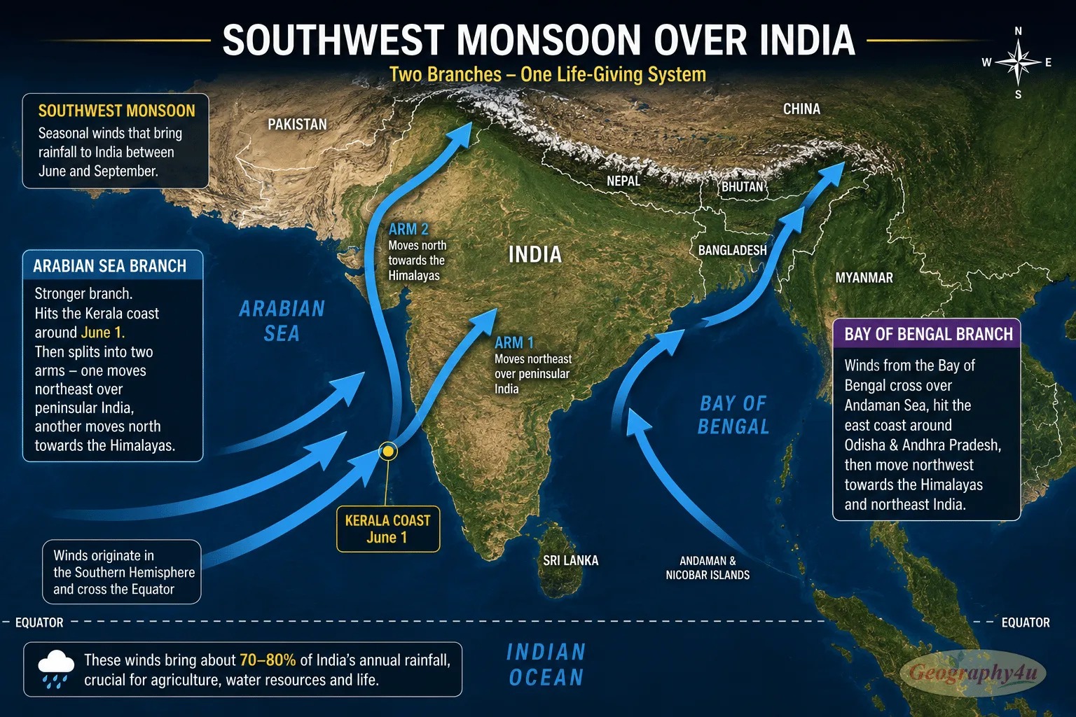
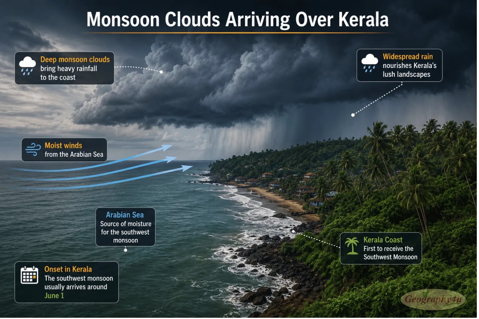
The Arabian Sea Branch arrives at the Kerala coast around June 1 — a date so consistent that the India Meteorological Department officially forecasts and announces it each year. It then splits: one arm moves northeast over peninsular India, the other crosses the Western Ghats and advances north along the Arabian Sea coast toward Gujarat and Rajasthan.The Bay of Bengal Branch enters through Assam and northeastern India in late May, moves westward across the entire Gangetic Plain, and eventually meets the Arabian Sea Branch in northwestern India by mid-July. At that point, the monsoon covers the entire country.
The Tibetan Plateau: The Monsoon’s Hidden Amplifier
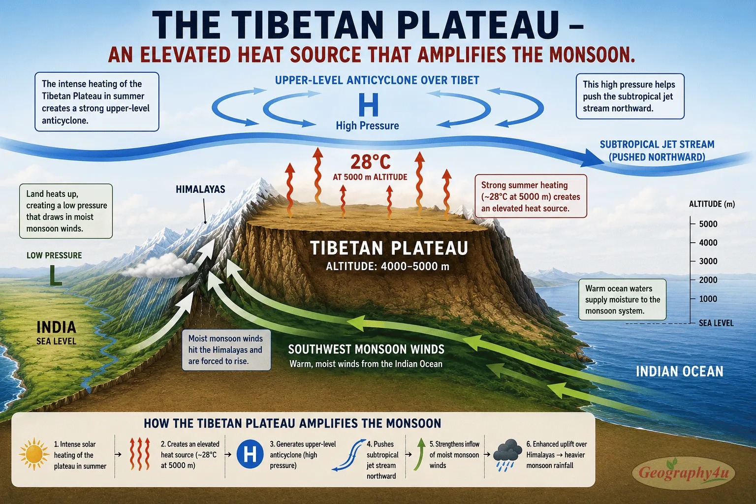
The Tibetan Plateau — the highest and largest plateau on Earth, averaging 4,000-5,000 meters in elevation — plays a role in the Indian monsoon that took scientists decades to understand. By May, the plateau’s surface reaches 28°C — extraordinarily warm for that altitude. This creates a powerful anticyclone (high-pressure system) in the upper atmosphere that pushes the subtropical jet stream northward. This displacement of the jet stream is one of the key triggers for monsoon onset.Think of the Tibetan Plateau as a gigantic heating element suspended 5 km above sea level. It amplifies the land-sea temperature contrast that drives the monsoon, making the Indian monsoon far stronger than it would be on a flat continent.
Related read: How Plate Tectonics Built the Himalayas and the Tibetan Plateau
The Monsoon’s Withdrawal: September to November
The monsoon does not end abruptly. It withdraws — retreating from north to south, roughly reversing the pattern of its advance. Withdrawal begins from northwestern India in early to mid-September, as temperatures drop and the thermal low over the continent weakens. By early October, the monsoon has retreated from northern India. By late November, it fully withdraws from the southern tip of the peninsula.During withdrawal, the retreating monsoon picks up moisture from the Bay of Bengal and delivers it to southeastern India — which is why Tamil Nadu and parts of Andhra Pradesh receive their heaviest rainfall in October and November, after the rest of India has dried out. This is the Northeast Monsoon in action — the second, smaller monsoon system that many people overlook.
Western Disturbances: India’s Winter Rain
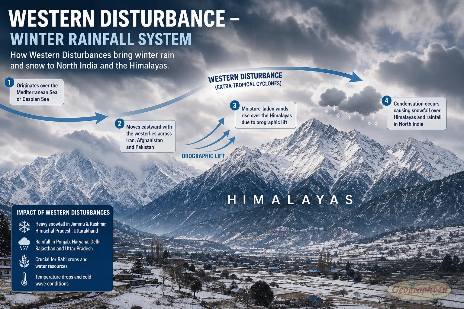
Outside the monsoon season, northwestern India still receives rainfall — but from a completely different source. Western Disturbances are extratropical cyclones that originate over the Mediterranean Sea and travel eastward through Iran, Afghanistan, and Pakistan into northwest India. They bring winter rains (October-March) to Punjab, Haryana, Himachal Pradesh, Jammu and Kashmir, and Uttarakhand.These winter rains are critical for the rabi (winter) crop — especially wheat. India is the world’s second-largest wheat producer, and without Western Disturbances, the entire wheat belt of northwest India would receive insufficient winter moisture. Western Disturbances also bring the snowfall to the Himalayas that feeds India’s major rivers during spring and summer snowmelt — creating a year-round water supply chain that begins with Mediterranean weather systems and ends in Indian rivers thousands of kilometers away.
Monsoons Around the World
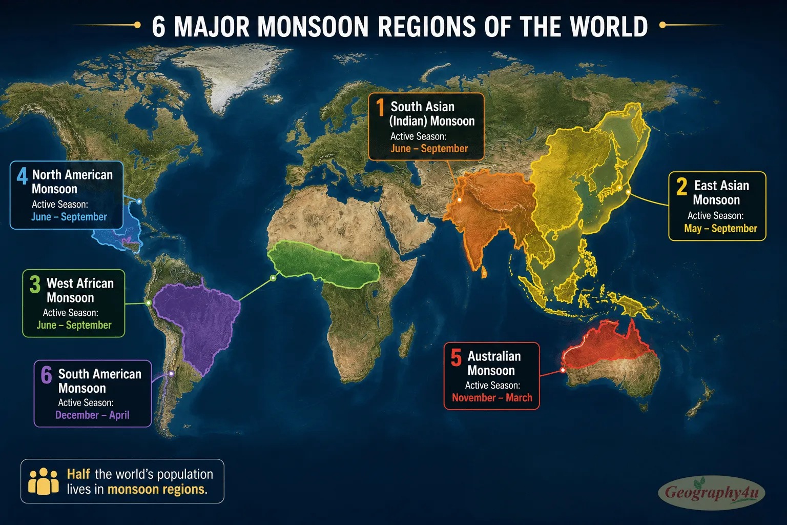
The Indian monsoon dominates headlines, but it is not the only monsoon on Earth. Five other major monsoon systems shape weather and agriculture across three continents.
| Monsoon System | Region | Season | Key Feature |
|---|---|---|---|
| South Asian (Indian) | India, Bangladesh, Pakistan, Myanmar | June-September | Largest and most intense. 80% of India’s rain. Two branches. |
| East Asian | China, Japan, Korea, SE Asia | May-September | Drives the “plum rain” season in China and Japan. |
| West African | Sahel, Nigeria, Ghana | June-September | Feeds rain-fed agriculture for 300+ million people. Sahel drought of 1970s-80s killed hundreds of thousands. |
| North American | Arizona, New Mexico, NW Mexico | July-September | Smaller but genuine monsoon. 40-70% of Sonoran Desert annual rain. Triggers haboobs (dust storms). |
| Australian | Northern Australia (Darwin, Cairns) | December-March | Southern Hemisphere summer. Darwin: 1,700+ mm wet season, virtually zero in dry. Highest variability. |
| South American | Amazon basin, central Brazil | October-March | Feeds the Amazon River system. Deforestation threatens to weaken the “flying rivers.” |
The North American Monsoon: America’s Own Monsoon
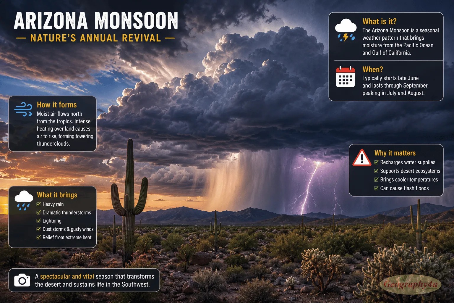
Most Americans are surprised to learn their country has a monsoon. The North American Monsoon — also called the Arizona monsoon or Southwest monsoon — brings summer thunderstorms to the desert Southwest from July through September. It provides 40-70 percent of annual rainfall to the Sonoran Desert region and is critical for recharging groundwater and supporting desert ecosystems.The mechanism is the same: intense solar heating creates a thermal low over the Mexican Plateau and the Desert Southwest. Moist air from the Gulf of California and the Gulf of Mexico flows inland, producing afternoon and evening thunderstorms that can be violent and spectacular. Before the rain arrives, the dry air often kicks up massive dust storms called haboobs — walls of brown dust that can engulf entire cities like Phoenix and Tucson.
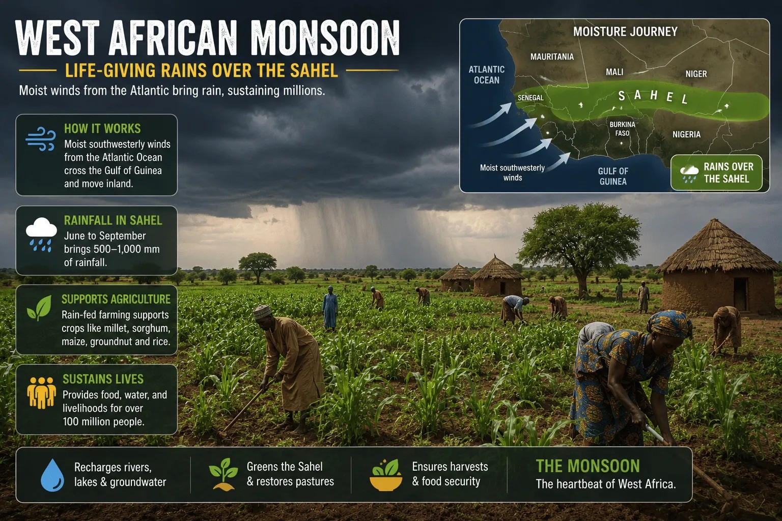
The West African Monsoon: Life and Death in the Sahel
The West African monsoon brings essential rainfall to the Sahel — the semi-arid transition zone between the Sahara Desert and the humid savannas to the south. Countries like Mali, Niger, and Burkina Faso depend almost entirely on this seasonal rainfall for crops like millet, sorghum, and peanuts. A shift of just 100 kilometers in the monsoon front’s northernmost reach can mean the difference between adequate harvest and devastating drought.This is not hypothetical. The prolonged Sahel drought of the 1970s and 1980s, linked to weakening of the West African monsoon driven by sea surface temperature changes, killed hundreds of thousands of people and displaced millions. It remains one of the worst climate-related humanitarian disasters in modern history.
The East Asian Monsoon: Plum Rains and Typhoons
The East Asian monsoon affects China, Japan, Korea, and Southeast Asia. In China and Japan, the monsoon’s arrival is called the “plum rain” season (meiyu in Chinese, baiu in Japanese) — named because it coincides with the ripening of plums. This front brings weeks of persistent drizzle and overcast skies to the Yangtze River valley, Korea, and southern Japan in June and July.The East Asian monsoon also fuels the typhoon season in the western Pacific. Warm, moist monsoon air provides the energy that tropical cyclones need to form and intensify. The Philippines, Taiwan, and southern Japan bear the brunt of these storms, which are among the most destructive natural hazards in the region.
The Australian Monsoon: The Southern Hemisphere’s Wet Season
Because Australia is in the Southern Hemisphere, its monsoon operates from December to March — when the Southern Hemisphere tilts toward the Sun. The city of Darwin in the Northern Territory receives over 1,700 mm of rain during the wet season but virtually no rain during the dry season, creating one of the starkest seasonal contrasts of any city on Earth.The Australian monsoon has the highest year-to-year variability of any monsoon system, largely because of its strong connection to ENSO. El Niño years typically bring drought to northern Australia, while La Niña years bring flooding. This variability extends to the Great Barrier Reef, where monsoon-driven freshwater runoff affects coral health, and to the tropical savannas, where the monsoon determines the fire cycle that shapes the landscape.
Why Some Places Get Meters of Rain and Others Get Almost None
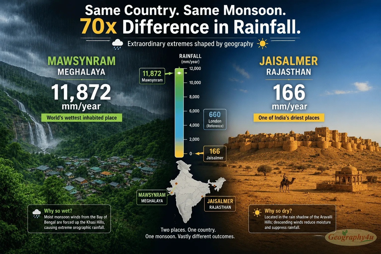
Monsoon rainfall is not evenly distributed. Within a single country, rainfall can vary by a factor of 70 — producing some of the most extreme rainfall contrasts on Earth.
The Wettest Places on Earth
Mawsynram, Meghalaya (northeast India) receives an average of 11,872 mm of rain per year — the wettest inhabited place on Earth. Its neighbor Cherrapunji (Sohra) averages 11,430 mm and once recorded 26,471 mm in a single year (1860-61), a record that stood for over a century.Why? The Bay of Bengal branch of the monsoon funnels moisture-laden air into a narrow valley that faces directly south. When this air hits the steep Khasi Hills, it is forced to rise rapidly — a process called orographic lift. The air cools, cannot hold its moisture, and dumps astonishing quantities of rain on the windward slopes.
The Driest Places in a Monsoon Country
Just 2,000 km to the west, Jaisalmer in Rajasthan’s Thar Desert receives approximately 166 mm per year — less than 1.5 percent of Mawsynram’s total. By the time the Arabian Sea Branch reaches western Rajasthan, most of its moisture has already been precipitated over the Western Ghats and central India. The hot Thar Desert also creates subsidence (sinking air) rather than convergence, further suppressing rainfall.
The Western Ghats: India’s Rainfall Dividing Line
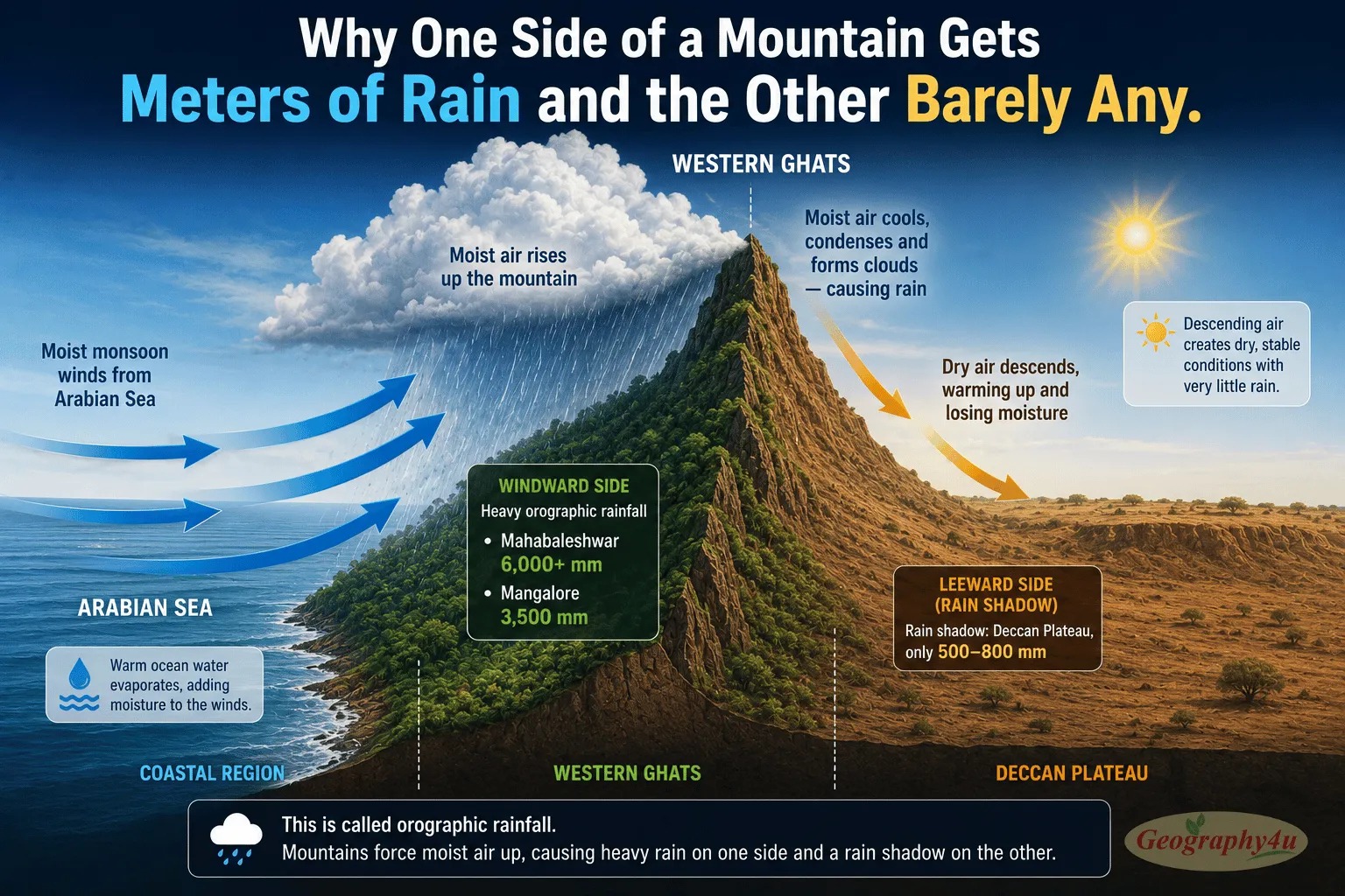
The Western Ghats — a 1,600-km mountain range running along India’s western coast — are the single most important topographic feature in the Indian monsoon system. They force the Arabian Sea Branch to rise steeply, wringing out moisture on the windward (western) side: Mahabaleshwar receives 6,000+ mm, Mangalore 3,500 mm. The leeward (eastern) side — the Deccan Plateau interior — sits in a rain shadow, receiving only 500-800 mm. This is why Karnataka’s and Maharashtra’s interior is dry while the Konkan coast just 100 km to the west is drenched.
Monsoon Breaks: When the Rain Stops Mid-Season
The monsoon is not four months of continuous rain. It pulses — with periods of intense rainfall (active phases) alternating with periods of little or no rain (break phases). Understanding this rhythm is critical for anyone trying to predict crop yields, manage water resources, or plan construction schedules in monsoon regions.
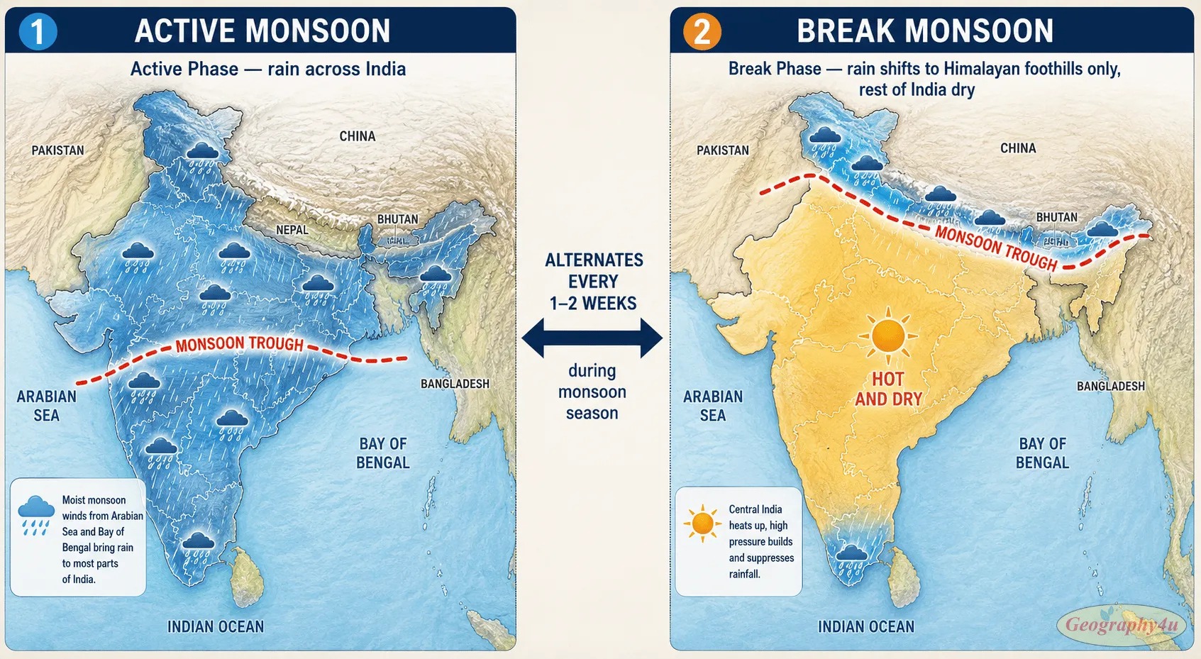
During a monsoon break, the monsoon trough — the low-pressure band that drives rainfall — shifts northward to the Himalayan foothills. Rain concentrates along the foot of the Himalayas and in the extreme south of India, while the vast middle of the country — the agricultural heartland — experiences dry, hot conditions. These breaks typically last 1-2 weeks before the monsoon trough returns to its normal position and active rainfall resumes.Extended or repeated breaks are what farmers and economists fear most. A single long break during the critical growing period for rice or cotton can reduce yields dramatically. The 2026 monsoon — forecast at only 90% of the long-period average — has seen more pronounced breaks than usual, adding to agricultural anxiety across India.
El Niño and the Monsoon: The 2026 Crisis
If you follow global weather, you have probably heard of El Niño. But you may not know that its most consequential impact anywhere on Earth is on the monsoon — specifically, the Indian monsoon.
How El Niño Suppresses the Monsoon
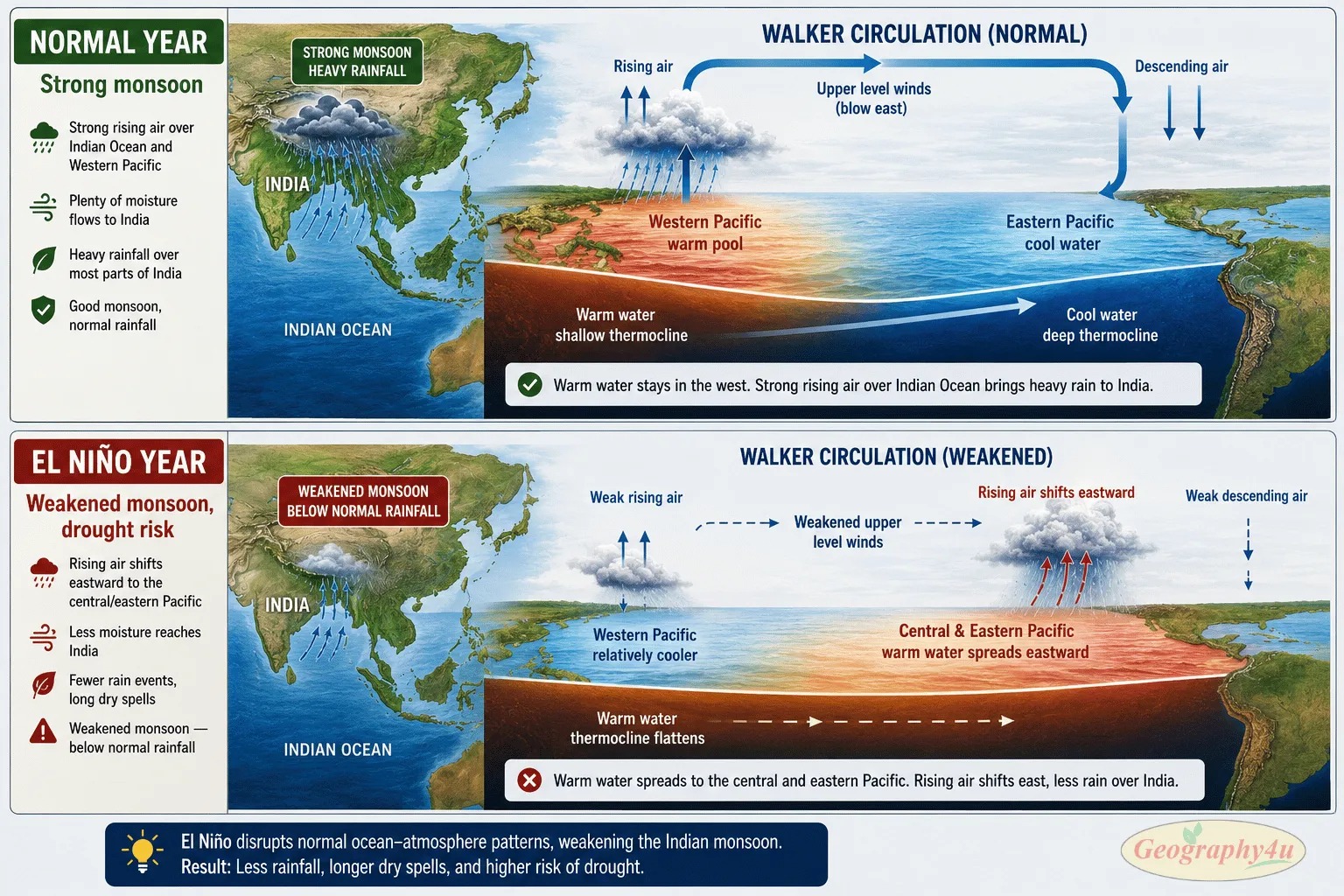
El Niño is a periodic warming of sea surface temperatures in the central and eastern Pacific Ocean. It disrupts the Walker Circulation — the large-scale east-west airflow pattern across the tropical Pacific. Under normal conditions, warm water pools in the western Pacific and Indian Ocean, supporting strong convection (rising air) over the monsoon region. During El Niño, this warm water shifts eastward toward the central Pacific. Convection weakens over the Indian Ocean, the pressure gradients that drive monsoon winds are disrupted, and the monsoon delivers less rainfall.The correlation is well-documented: of the 13 strongest El Niño events since 1950, 10 coincided with below-normal Indian monsoons.
The 2026 El Niño: Potentially Record-Setting
The 2026 monsoon is unfolding under some of the most challenging atmospheric conditions in recent years:
-
- IMD has revised its 2026 monsoon forecast down to 90% of the Long Period Average (LPA) — placing it in the “below normal” category, with a 60% probability of a fully deficient season.
-
- The World Meteorological Organization (WMO) projects an 80% likelihood of El Niño persisting through June-August 2026, with probabilities near or above 90% through at least November.
-
- Some forecasters warn of a possible “Super El Niño” — a record-breaking event that could suppress monsoon rainfall across all of South and Southeast Asia simultaneously.
-
- The Indian Ocean is warming faster than the global average, complicating traditional El Niño-monsoon relationships and making predictions more uncertain.
The 2026 monsoon: 90% of normal rainfall forecast. 60% chance of deficient season. El Niño developing. This matters for global food prices, commodity markets, and inflation — not just for India.
The Indian Ocean Dipole: The Other Variable
The Indian Ocean Dipole (IOD) — the temperature difference between the western and eastern Indian Ocean — also influences the monsoon, sometimes even more than El Niño. A positive IOD (western Indian Ocean warmer than eastern) tends to enhance monsoon rainfall, while a negative IOD suppresses it. In 2026, the IOD outlook adds further uncertainty to an already challenging forecast.
Related read: Climate Change in 2026: What the Latest Data Tells Us
How Climate Change Is Altering the Monsoon
Climate change is not simply making the monsoon wetter or drier. It is making it more unpredictable — which, for billions of people who plan their lives around the monsoon’s rhythm, may be worse than either outcome alone.
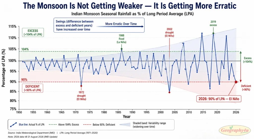
Climate models consistently project four trends for monsoon systems worldwide:1. Overall intensification. Warmer oceans evaporate more moisture, so the total amount of water vapor available to monsoon systems is increasing. This means monsoon rainfall is projected to increase globally over the coming decades — but not uniformly.2. More extreme events. Rainfall is becoming more concentrated in shorter, more intense bursts. The Valsad, Gujarat event of July 23, 2026 — 100+ cm in 24 hours — is exactly the type of extreme event climate models predict will become more frequent. More rain overall, but delivered in fewer, more violent episodes.3. More variable onset and withdrawal. The monsoon’s historically reliable arrival and departure dates are becoming less predictable. The June 1 onset at Kerala — a cultural and economic landmark in India — now has a wider range of uncertainty than in previous decades.4. Spatial redistribution. Some regions that historically received reliable monsoon rainfall are getting less, while others are getting more. This spatial shift is particularly dangerous because agricultural systems, water infrastructure, and urban planning are all built around historical rainfall patterns that may no longer hold.
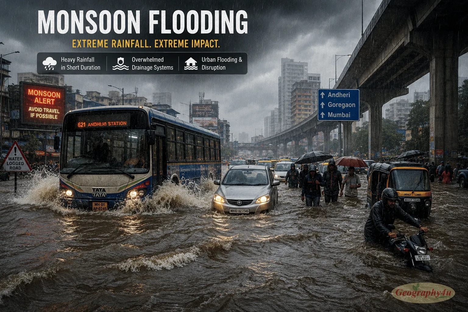
The net effect is not simply “more rain” but “more dangerous rain” — with increased flood risk and increased drought risk simultaneously, sometimes within the same season in the same country.
Why the Monsoon Affects Your Life (Even If You’ve Never Seen One)
If you live in the United States, Europe, or Australia, you might wonder why you should care about rainfall patterns in South Asia. The answer is economic: the monsoon is directly connected to global food prices, commodity markets, and inflation in ways that reach your grocery store and your investment portfolio.
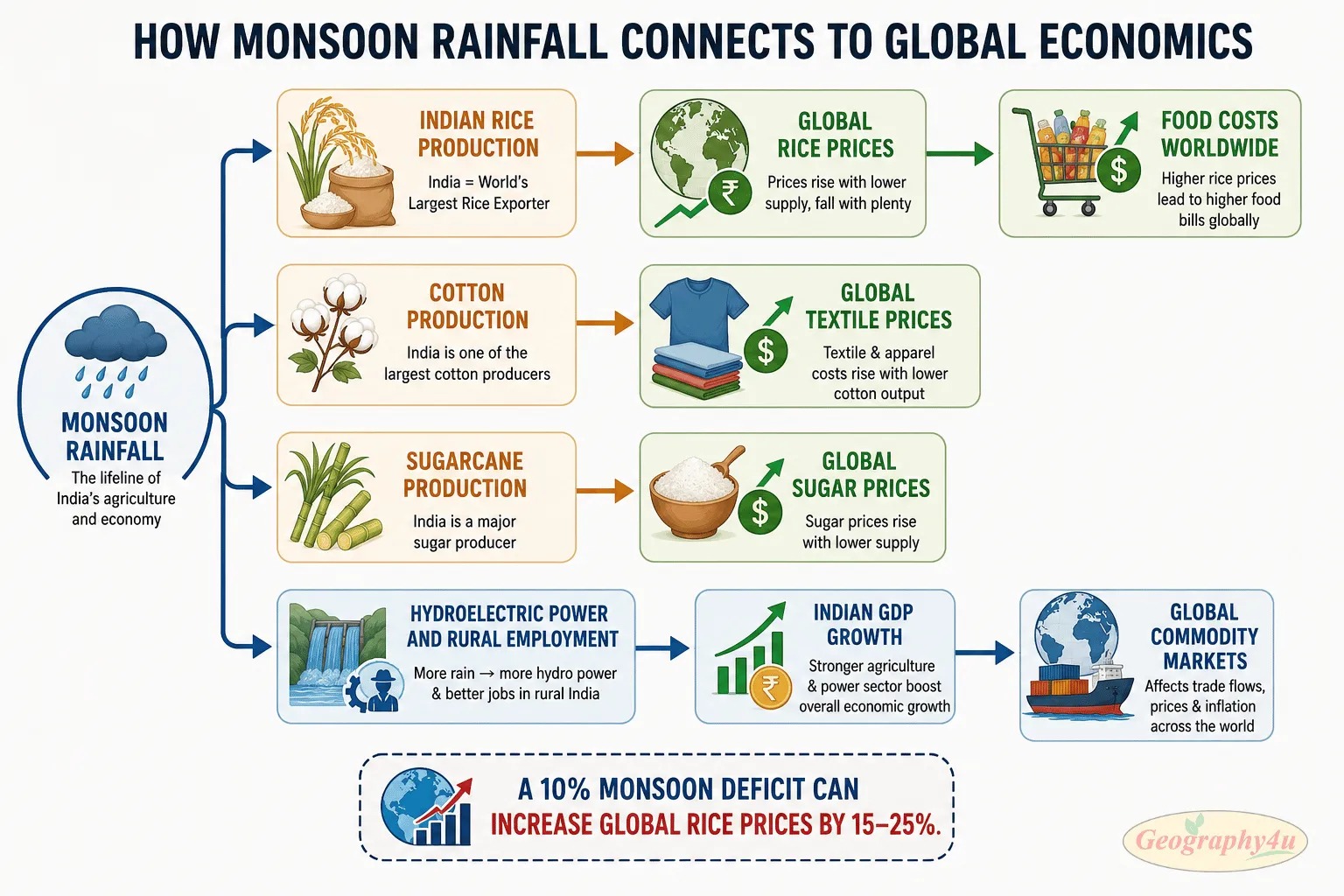
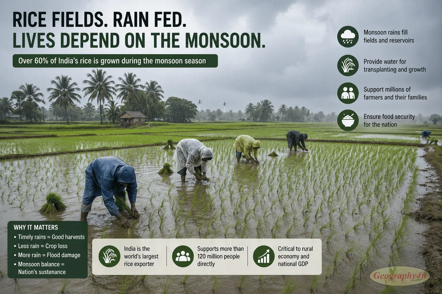
Rice: India is the world’s largest exporter of rice. A weak monsoon directly reduces Indian rice production, which tightens global supply and pushes up rice prices worldwide. Rice is a staple for over 3.5 billion people — when prices spike, it affects food security across Africa, Southeast Asia, and the Middle East.Sugar: India is the world’s second-largest sugar producer. Sugarcane is a water-intensive crop that depends heavily on monsoon rainfall. Weak monsoons reduce Indian sugar output, affecting global sugar prices and the food and beverage industries that depend on them.Cotton: India is one of the top cotton producers globally. Cotton is a kharif (monsoon-season) crop. Below-normal monsoon rainfall stresses cotton yields, feeding into global textile prices.Inflation: In India, food accounts for nearly 40% of the Consumer Price Index. A weak monsoon drives food prices up domestically, which affects India’s central bank interest rate decisions, the value of the Indian rupee, and by extension, global commodity and currency markets.A 10% deficit in monsoon rainfall can shave 0.5-1.0 percentage points off India’s GDP growth — in a $3.9 trillion economy that is the world’s fifth-largest. Commodity traders, agricultural futures markets, and central bankers worldwide monitor the Indian monsoon forecast with the same intensity they monitor US Federal Reserve statements.
Frequently Asked Questions
What is a monsoon in simple terms?
A monsoon is a seasonal reversal of wind direction that causes a dramatic shift between wet and dry seasons. During summer, land heats faster than the ocean, creating low pressure over the continent. Moisture-laden winds rush in from the ocean, producing heavy rainfall. In winter, the process reverses — cool, dry winds blow from the land toward the ocean. Monsoons affect roughly half the world’s population and bring 80% of annual rainfall to regions like India, Southeast Asia, and West Africa.
Is a monsoon the same as a hurricane?
No. A monsoon is a season-long wind pattern covering an entire continent, lasting months. A hurricane is a single storm system, typically lasting days. Monsoons bring sustained rainfall over weeks, while hurricanes bring intense rainfall over hours. However, monsoons can generate individual cyclonic storms within the broader monsoon system.
Does the United States have a monsoon?
Yes. The North American Monsoon brings summer thunderstorms to Arizona, New Mexico, and northwestern Mexico from July through September. It provides 40-70% of annual rainfall to the Sonoran Desert. While smaller than the Asian monsoon, it is a genuine monsoon system with a seasonal wind reversal driven by differential heating of the Mexican Plateau.
How does El Niño affect the monsoon?
El Niño typically weakens the Indian and Southeast Asian monsoons by altering the Walker Circulation — the east-west airflow pattern across the Pacific. During El Niño, warm water shifts eastward, disrupting the pressure gradients that drive monsoon winds. The 2026 monsoon is forecast at only 90% of normal rainfall, partly due to a developing El Niño that the WMO says has an 80% likelihood of continuing through November 2026.
Why does Cherrapunji get so much rain?
Cherrapunji (Sohra) in Meghalaya, India receives approximately 11,430 mm of rain per year because of orographic lift. The Bay of Bengal branch of the monsoon is funneled into a narrow valley that faces directly south. When the moisture-laden winds hit the Khasi Hills, they are forced to rise steeply, cool rapidly, and dump enormous amounts of rain. Nearby Mawsynram (11,872 mm average) is the current wettest place on Earth by the same mechanism.
When does the monsoon season start and end?
It depends on the region. The Indian Southwest Monsoon typically arrives at the Kerala coast around June 1 and withdraws from northwest India by mid-September, with full withdrawal by late November. The North American Monsoon runs from July to September. The West African monsoon runs from June to September. The Australian monsoon operates from December to March (Southern Hemisphere summer).
Is the monsoon getting stronger because of climate change?
Climate models project that monsoon rainfall will intensify overall because warmer oceans evaporate more moisture. However, the pattern is becoming more erratic — with more extreme wet events and more extreme dry spells within the same season, less predictable onset dates, and shifting spatial distribution. The net effect is not simply “more rain” but “more variable and more dangerous rain,” with increased flood and drought risk simultaneously.
What is a monsoon break?
A monsoon break is a temporary pause or weakening of monsoon rainfall lasting 1-2 weeks during the active monsoon season. During a break, rain concentrates near the Himalayan foothills and the extreme south of India while most of the country experiences dry, hot conditions. The monsoon then resumes. Extended or repeated breaks can severely reduce seasonal rainfall totals and damage crops.
Final Thoughts: The Weather System That Feeds Half the World
For 5,000 years, civilizations across Asia, Africa, and the Americas have organized themselves around the monsoon. Festivals celebrate its arrival. Temples were built to honor the rains. Agricultural calendars, marriage seasons, military campaigns, and trade routes all historically aligned with the monsoon’s rhythm.That relationship has not changed. In 2026, with a developing El Niño threatening to suppress rainfall, with climate change making the monsoon more erratic, and with a global population that has doubled since 1970, the monsoon matters more — not less — than it ever has. The crops it waters feed half the planet. The rivers it fills provide drinking water to billions. The economies it supports are among the world’s fastest-growing.The monsoon is not just an exotic weather phenomenon that happens far away. It is the single largest seasonal redistribution of heat and moisture on Earth. And its next move — this week, this month, this season — will affect food prices, commodity markets, and economic conditions worldwide.That meter of rain that fell on Valsad, Gujarat yesterday? It didn’t just flood roads in western India. It moved markets in Chicago, London, and Singapore.