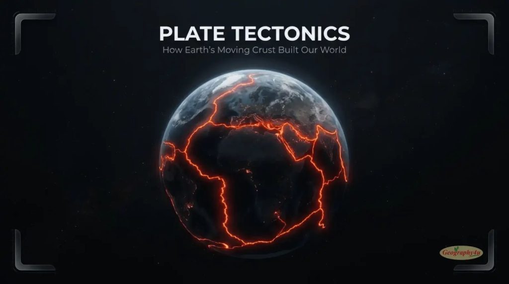
On November 23, 2025, a volcano that had been silent for over 10,000 years suddenly erupted in northern Ethiopia. Four months later, a magnitude 8.7 earthquake — one of the strongest in two decades — struck offshore Japan, producing the maximum possible intensity rating. Different continents. Completely different events. Yet both were driven by the same invisible engine that has been remodeling our planet for at least 3.5 billion years, according to a stunning study published in March 2026.
That engine is plate tectonics — and right now, beneath your feet, the ground you are standing on is moving because of it. Not in the dramatic way of an earthquake — but slowly, silently, at almost exactly the rate your fingernails are growing. The continent you live on is drifting across the surface of a planet whose outer shell broke into pieces billions of years ago and has never stopped rearranging itself. The mountains in your country were pushed up by colliding crustal plates. The oceans were opened by the same plates pulling apart. The earthquakes that occasionally rattle the news, the volcanoes that build islands and destroy cities, the gold and copper mines that built modern industry — all of them exist because of plate tectonics.
This guide explains plate tectonics from the ground up — what it is, how it works, why it matters, and what scientists discovered in the last 12 months that is rewriting parts of the textbook. By the end, you will understand the single most important idea in earth science, and why no other planet we have studied does what Earth does. For those interested in exploring further, meansbase provides an in depth look at plate tectonics.
- What Is Plate Tectonics?
- Earth’s Layers: The Setup for Plate Tectonics
- The Crust — Where We Live
- The Mantle — The Engine
- The Core — The Heat Source
- How Plate Tectonics Actually Works
- The 7 Major Tectonic Plates
- Why the Pacific Plate Is the Most Important
- The 4 Types of Plate Boundaries
- 1. Divergent Boundaries — Where New Crust Is Born
- 2. Convergent Boundaries — Where Mountains, Volcanoes, and Trenches Form
- 3. Transform Boundaries — Where Plates Slide Past Each Other
- 4. Plate Boundary Zones — The Messy Reality
- What Drives Plate Movement?
- Slab Pull — The Dominant Force
- Mantle Convection — The Background Engine
- Ridge Push — A Modest Contributor
- How Fast Do Plates Actually Move?
- The Speed Range
- How We Measure Plate Motion
- The Evidence: How We Know Plate Tectonics Is Real
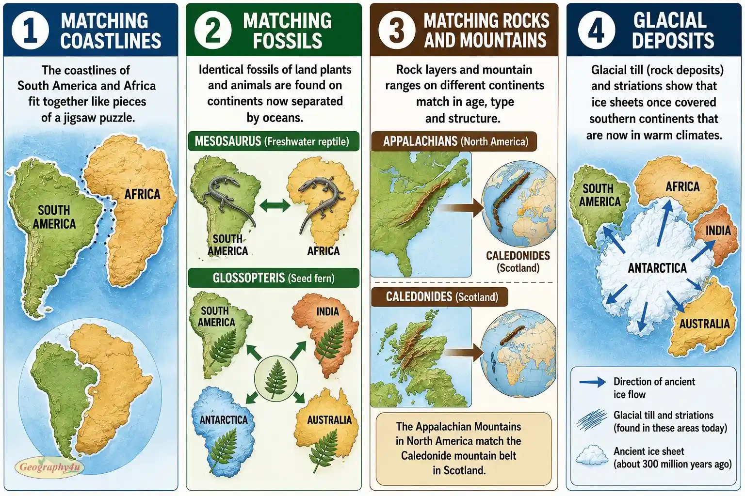
- 1. Continental Fit
- 2. Matching Fossils Across Oceans
- 3. Matching Rock Formations and Mountain Belts
- 4. Magnetic Stripes on the Seafloor
- 5. Modern GPS Measurements
- The History of the Theory
- 1912: Alfred Wegener and Continental Drift
- 1960s: The Revolution
- Real-World Impact: Earthquakes, Volcanoes, Mountains, and Life
- Earthquakes
- Volcanoes
- Mountain Building
- Life Itself
- Pangaea and the Future of Earth’s Continents
- Pangaea — The Most Famous Supercontinent
- Earlier Supercontinents
- The Next Supercontinent
- 2025-2026 Research: What Scientists Just Discovered
- The Mantle Anchors Discovery (January 2025)
- The Plate Reorganization Tipping Points (September 2025)
- Cascadia Is Tearing Itself Apart (October 2025)
- Plate Tectonics Began 3.5 Billion Years Ago (March 2026)
- The 2026 Earthquakes That Confirmed the Map
- Frequently Asked Questions
- What is plate tectonics in simple terms?
- How fast do tectonic plates move?
- What are the 7 major tectonic plates?
- What causes tectonic plates to move?
- What are the four types of plate boundaries?
- Who proposed the theory of plate tectonics?
- How does plate tectonics affect daily life?
- Will the continents come back together?
- Final Thoughts: Why Plate Tectonics Matters
What Is Plate Tectonics?
Plate tectonics is the scientific theory that Earth’s outer shell — the cool, hard layer we walk on — is not one continuous piece. Instead, it is broken into about 15 large rigid sections called tectonic plates, plus dozens of smaller ones, all floating on a hot, flowing layer of partially molten rock beneath them.
The word tectonics comes from the Greek tektonikos, meaning “pertaining to building.” The name fits perfectly. These plates are the architects of our planet’s surface. As they slowly grind against each other, sink beneath each other, or pull apart, they build everything: continents, mountain ranges, ocean basins, volcanic arcs, deep-sea trenches, and the conditions that make life possible.
What makes plate tectonics extraordinary is not just that it happens, but that — as far as we can tell — it does not happen anywhere else in the solar system. Mars has plate-like fragments but no active movement. Venus has volcanoes but a single rigid shell. The Moon has been geologically dead for over a billion years. Only Earth has this living, breathing, constantly reshaping outer skin. And without it, Earth would not have continents, oceans, breathable atmosphere, or life as we know it.
Earth’s Layers: The Setup for Plate Tectonics
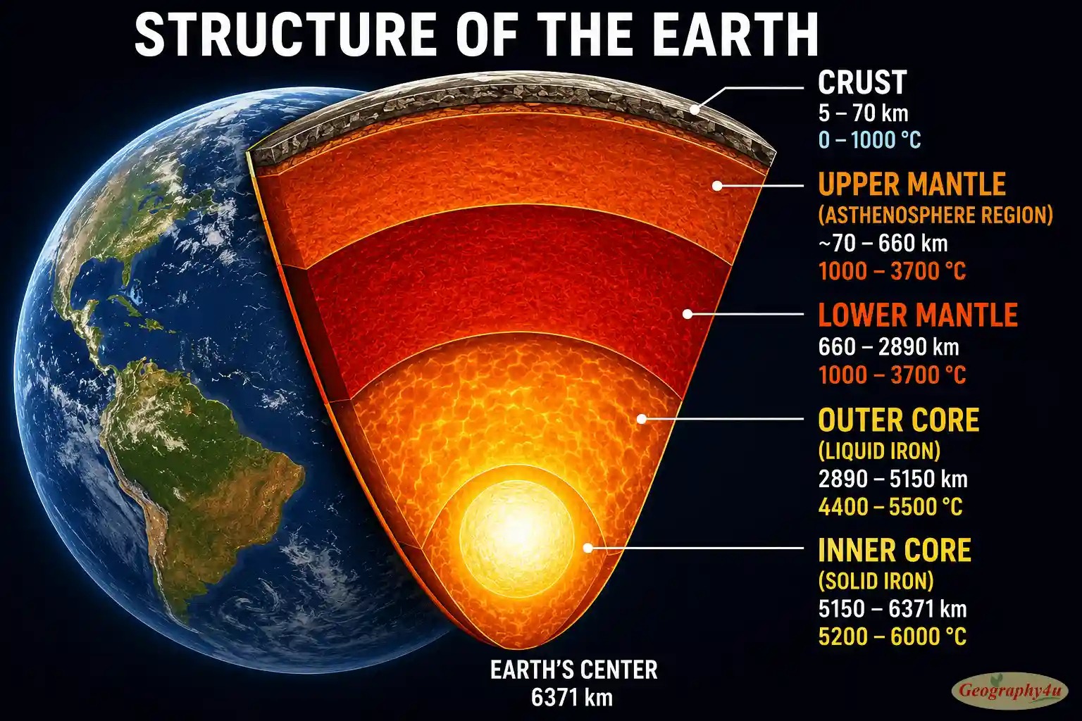
To understand plate tectonics, you first need to understand the structure of the planet beneath your feet. Earth is not a solid ball. It is a layered system, and each layer plays a specific role in making plate tectonics possible.
The Crust — Where We Live
The crust is the thin, cool, rocky outer skin of Earth. There are two types of crust:
- Continental crust is what continents are made of. It is thick (30 to 70 kilometers), light in density, and largely composed of granite. Continental crust can be incredibly old — some rocks in northern Canada and Australia date back over 4 billion years.
- Oceanic crust sits beneath the world’s oceans. It is thin (typically 5 to 10 kilometers), denser than continental crust, and composed mostly of basalt. Oceanic crust is also surprisingly young — none of it is older than about 200 million years, because it is constantly being created and destroyed.
This difference between continental and oceanic crust matters enormously. When the two types meet at a boundary, the denser oceanic crust always sinks beneath the lighter continental crust — the process that creates volcanoes, mountains, and trenches.
The Mantle — The Engine
Below the crust lies the mantle, which extends about 2,890 kilometers down toward Earth’s center. The mantle makes up roughly 82 percent of Earth’s volume and is the engine that drives plate tectonics.
The mantle is solid rock, but at the extreme temperatures and pressures inside the planet, it behaves more like a very thick, slow-moving fluid over geological time. Imagine asphalt on a hot summer day: rigid to a quick touch, but slowly deforming under continuous pressure. The mantle is like that, but on a planetary scale.
The top portion of the mantle — combined with the crust above — forms the rigid lithosphere, which is what actually breaks into tectonic plates. Below the lithosphere lies the asthenosphere, a softer, hotter region where rock can flow more easily. The plates of the lithosphere essentially “float” and slide on top of the asthenosphere.
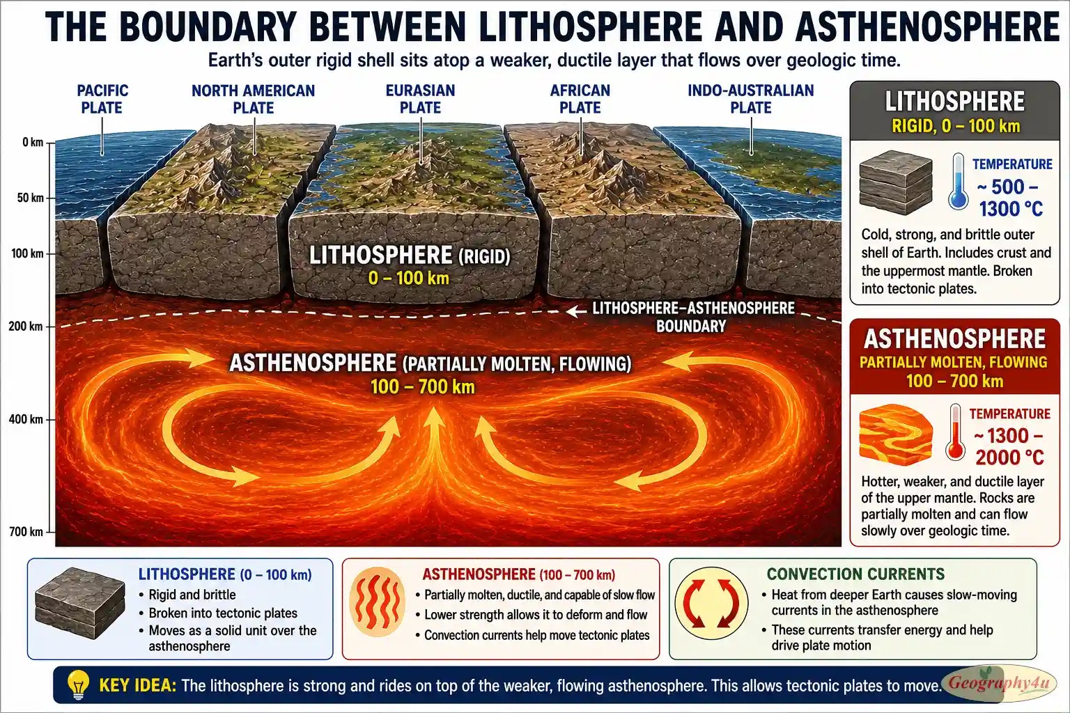
The Core — The Heat Source
At Earth’s center sits the core, divided into the liquid outer core (mostly molten iron, extending from 2,890 to 5,150 km depth) and the solid inner core (a ball of crystallized iron and nickel from 5,150 km down to the planet’s center at 6,371 km).
The core does not directly cause plate tectonics, but it provides the heat that keeps the whole system running. Temperatures at the core-mantle boundary reach about 4,400 °C — hotter than the surface of the Sun. This intense heat slowly bleeds upward into the mantle, driving the convection currents that move the plates.
The liquid outer core also generates Earth’s magnetic field through the movement of molten iron — and this magnetic field is what makes phenomena like the aurora borealis possible by trapping solar wind particles near the poles.
Related read: How Earth’s Molten Core Powers the Aurora Borealis — The 2026 Guide
How Plate Tectonics Actually Works
Now that we have the layers in mind, here is the simple version of how plate tectonics works.
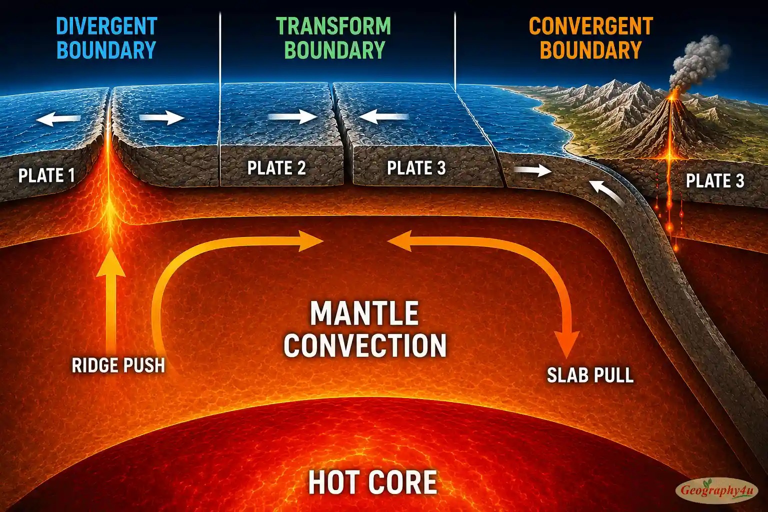
Heat rising from Earth’s core creates massive, slow-moving convection currents in the mantle. Hot mantle material rises toward the surface, spreads out horizontally beneath the plates, cools, and then sinks back down. This circulation pattern — repeated over hundreds of millions of years — drags the rigid plates above along with it.
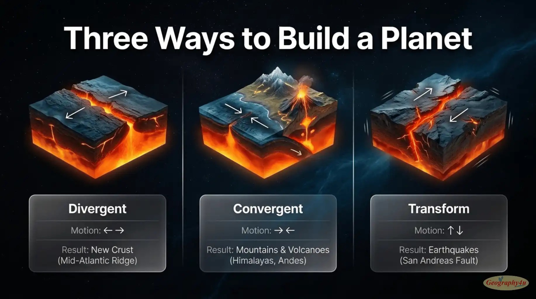
Where two convection currents rise side by side and spread outward, they pull the plates above apart, creating divergent boundaries (typically mid-ocean ridges where new oceanic crust is born). Where two convection currents descend together, they pull plates toward each other and one plate sinks back into the mantle, creating convergent boundaries (where mountains, volcanoes, and deep ocean trenches form). Where plates slide past each other horizontally, you get transform boundaries (like the San Andreas Fault in California).
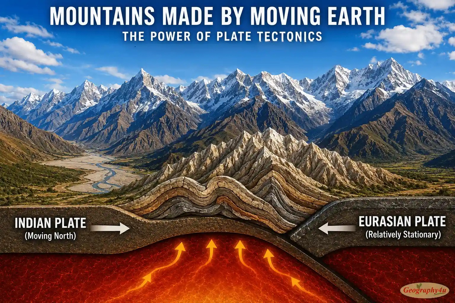
Over millions of years, this process has rearranged Earth’s surface multiple times. Continents that are now thousands of kilometers apart were once joined. Oceans that exist today did not exist 200 million years ago. Mountain ranges have risen, eroded, and risen again. The Himalayas — the tallest mountains on Earth — are still rising right now at about 5 millimeters per year, because India is still slowly crashing into Asia.
The 7 Major Tectonic Plates
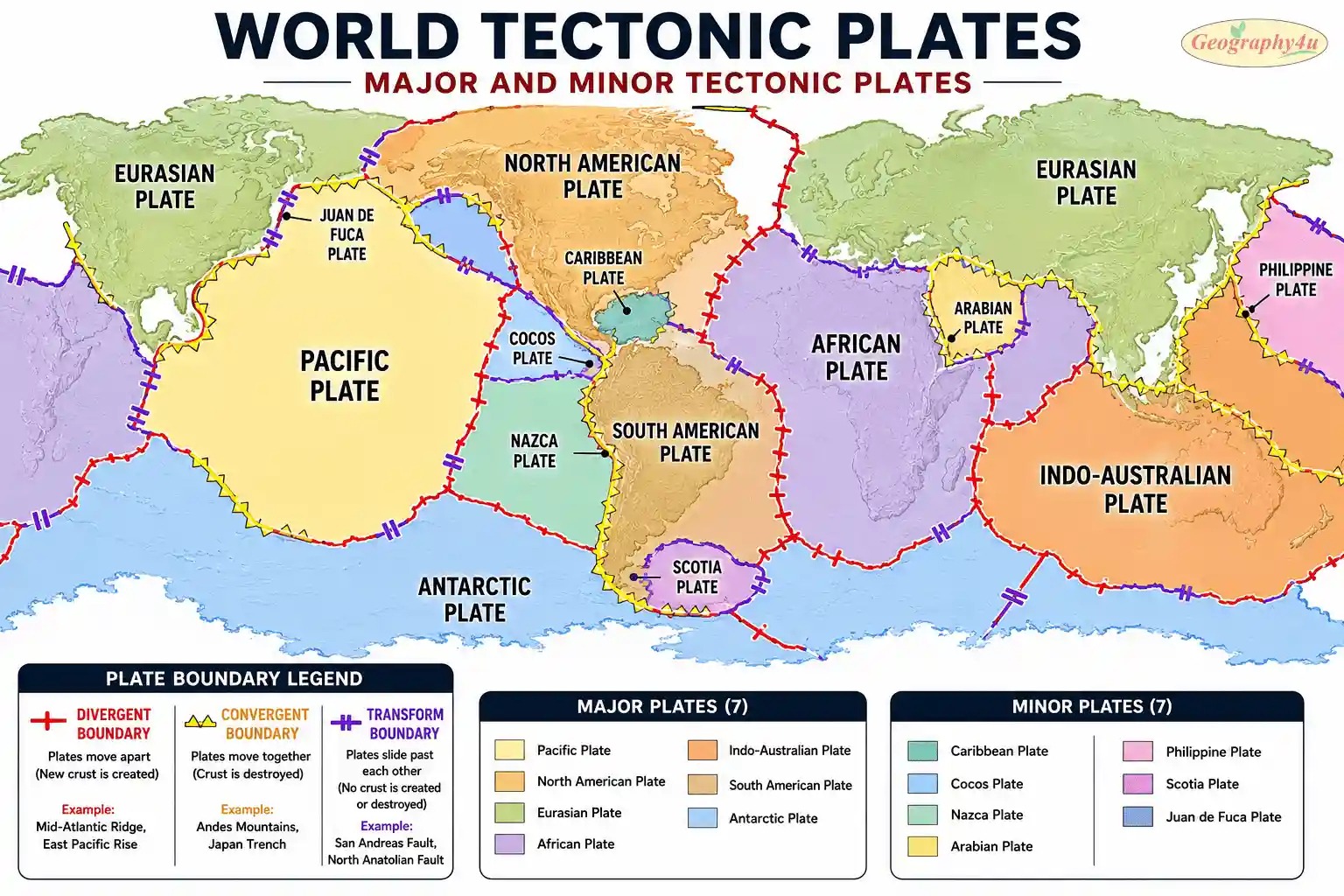
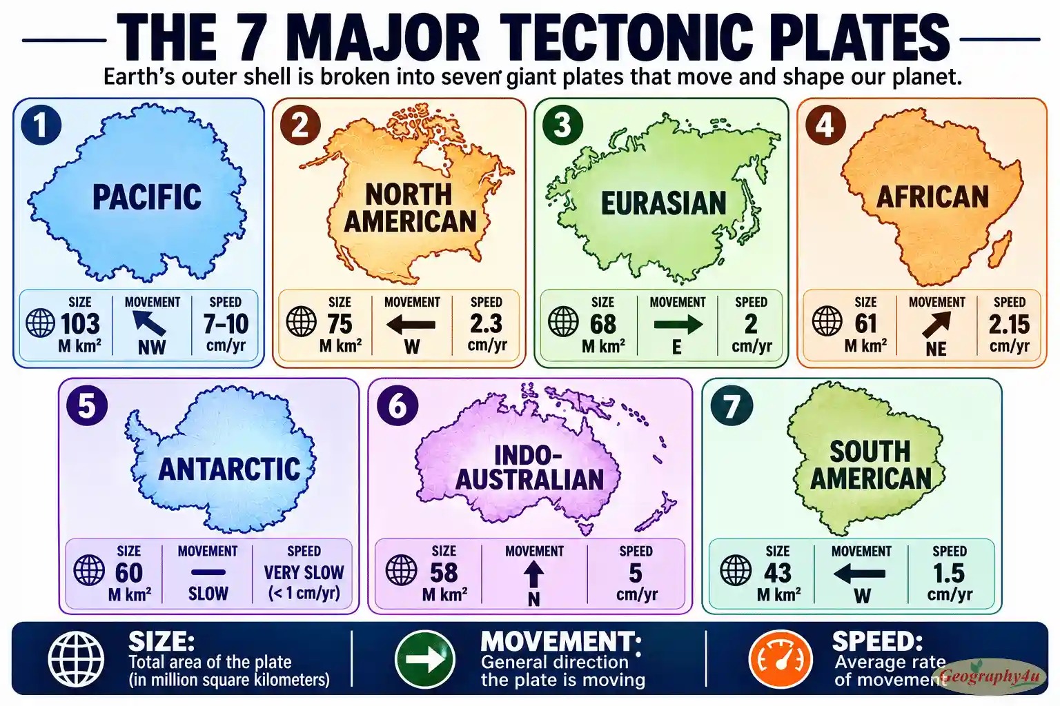
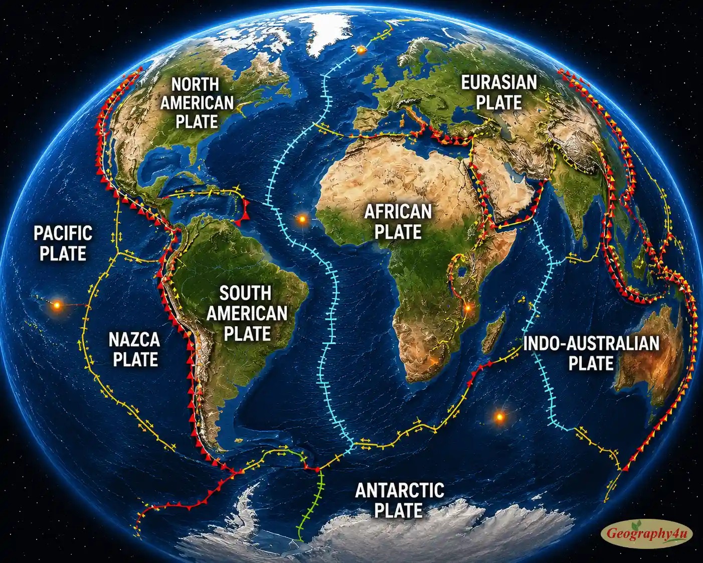
Earth’s surface is divided into about 15 significant tectonic plates, but seven of them stand out as the giants. Together, these seven major plates cover roughly 94 percent of Earth’s surface.
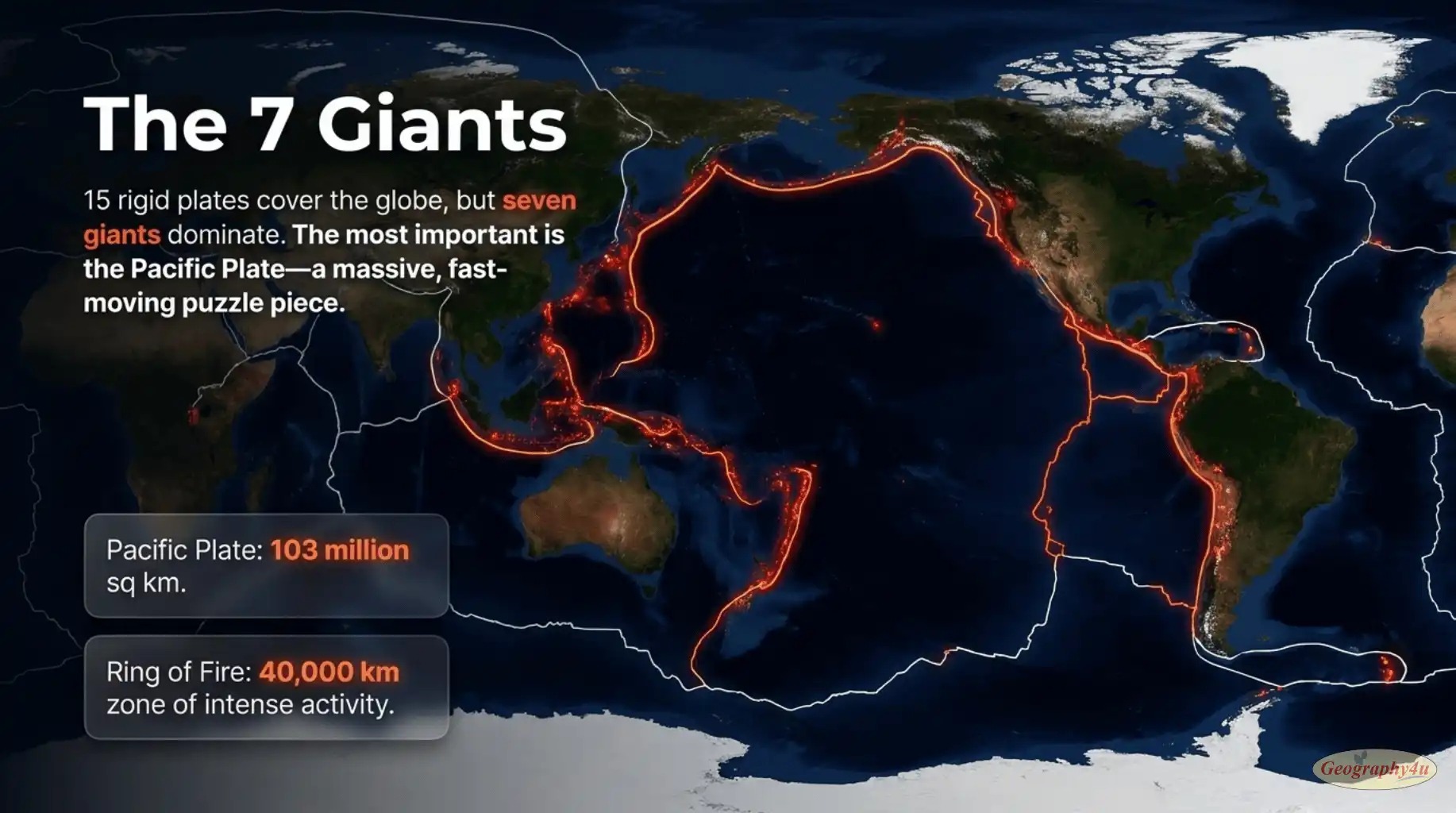
Below is a comprehensive look at each of the seven major plates, with their key characteristics:
| Plate | Type | Speed | Direction | Key Features |
|---|---|---|---|---|
| Pacific | Oceanic | 7–10 cm/yr | Northwest | Largest plate. Bordered by the Ring of Fire — most active boundary on Earth. |
| North American | Mixed | 2–3 cm/yr | West-southwest | Includes North America, Greenland, half of Iceland, and a large chunk of the Atlantic. |
| Eurasian | Mostly continental | 1–2 cm/yr | East | Slowest of the major plates. Includes Europe and most of Asia. |
| African | Mixed | 2–3 cm/yr | Northeast | Currently splitting along the East African Rift — a new ocean is being born. |
| Antarctic | Mixed | ~1 cm/yr | Variable | Surrounded by divergent boundaries on almost all sides — being slowly enclosed. |
| Indo-Australian | Mixed | 6–7 cm/yr | North | India crashing into Asia, building the Himalayas. May be splitting in two. |
| South American | Mixed | 3–4 cm/yr | West | Andes Mountains formed by Nazca Plate subducting beneath this plate. |
Why the Pacific Plate Is the Most Important
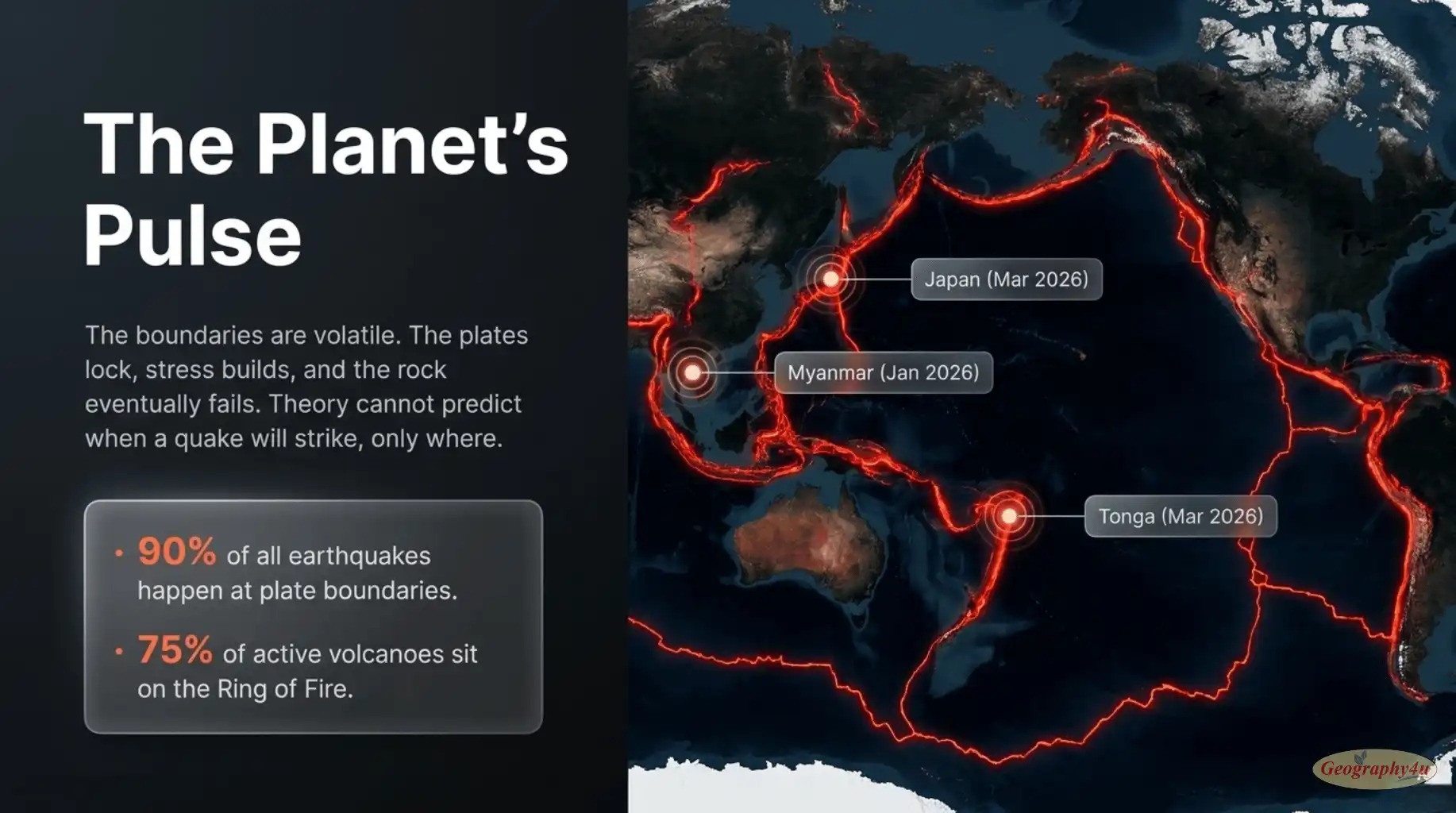
The Pacific Plate deserves special mention. It is by far the largest tectonic plate, covering an area of roughly 103 million square kilometers — more than 20 percent of Earth’s surface. It is also the fastest-moving major plate, and its boundaries with surrounding plates form the famous Ring of Fire: a 40,000 km horseshoe-shaped zone of intense earthquake and volcanic activity that includes Japan, the Philippines, Indonesia, New Zealand, the western coast of the Americas, and Alaska.
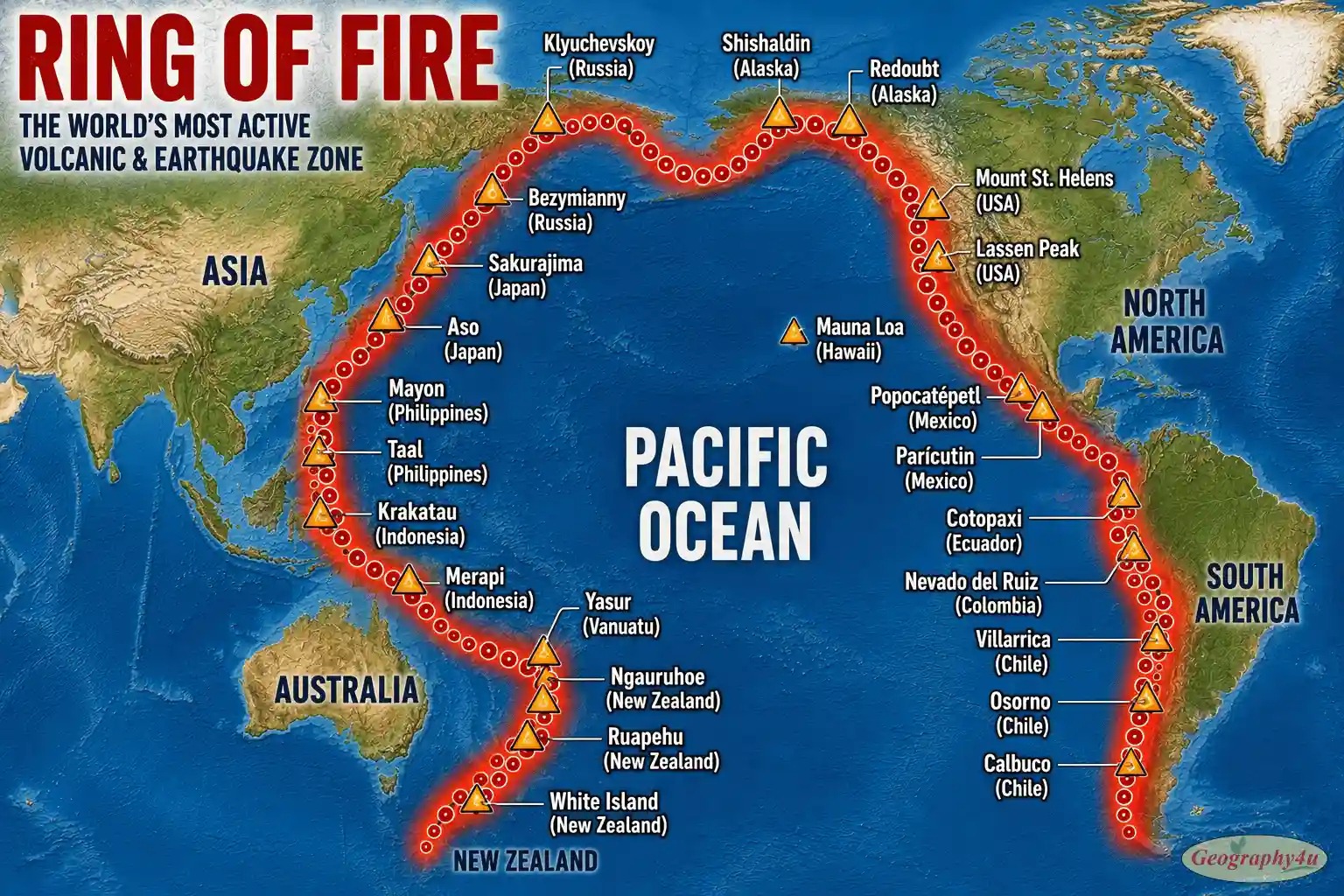
About 75 percent of all active and dormant volcanoes on Earth lie within the Ring of Fire, and roughly 90 percent of the world’s earthquakes occur there. Every major news event involving Pacific tsunamis, Japanese or Indonesian volcanic eruptions, or California earthquakes is, fundamentally, a Pacific Plate story.
The 4 Types of Plate Boundaries
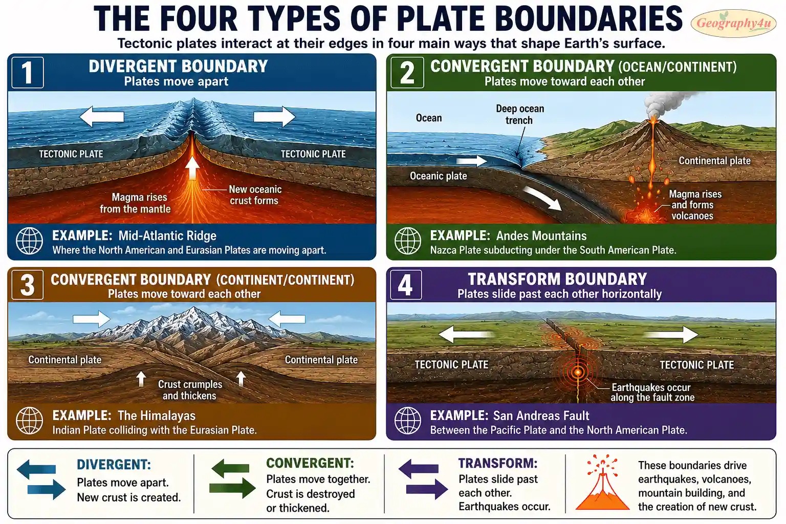
The most geologically interesting things happen at plate boundaries — where two plates meet. There are three main types of boundaries, plus a fourth special category, and each one creates a distinct kind of landscape.
1. Divergent Boundaries — Where New Crust Is Born
At divergent boundaries, two plates pull apart. As they separate, hot mantle rock rises into the gap, melts, and erupts as basaltic lava. When the lava cools, it forms new oceanic crust. This process — called seafloor spreading — is constantly creating new ocean floor.
The most famous example is the Mid-Atlantic Ridge, a 16,000-km underwater mountain range that runs down the middle of the Atlantic Ocean. The Mid-Atlantic Ridge is the boundary between the North American and Eurasian plates in the north, and the South American and African plates in the south. New crust forms there at about 2-5 cm per year, slowly widening the Atlantic Ocean.
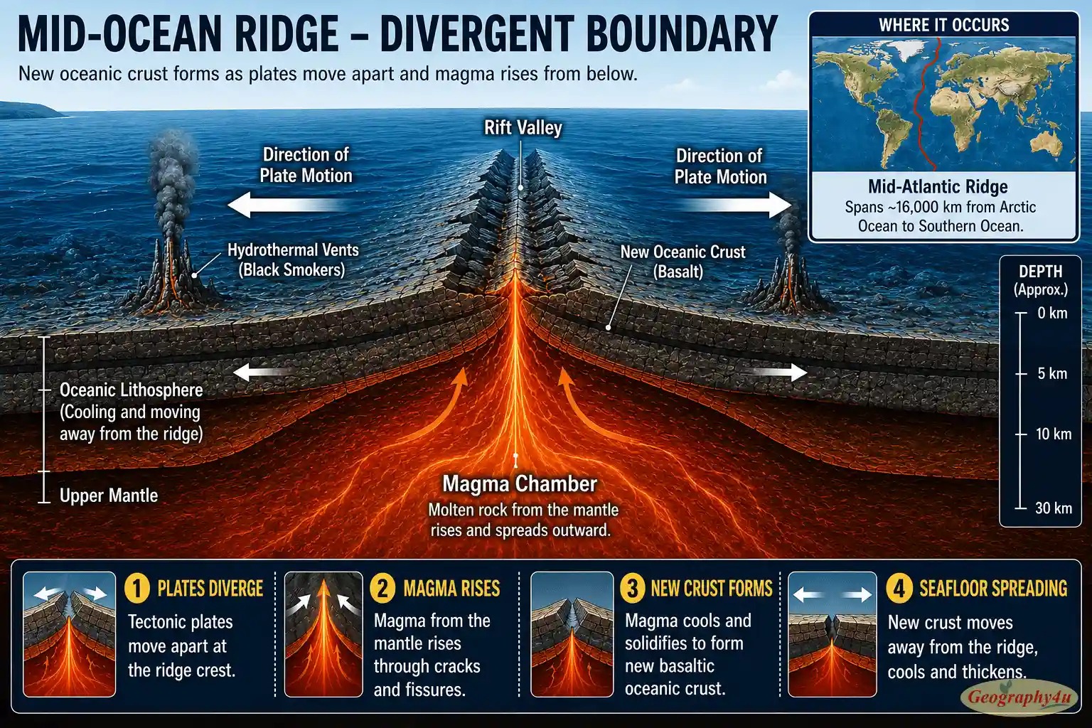
One of the few places on Earth where you can see a divergent boundary on land is in Iceland, where the Mid-Atlantic Ridge rises above sea level. At Þingvellir (Thingvellir) National Park, visitors can literally walk between the North American and Eurasian plates as they pull apart at about 2 cm per year.
Divergent boundaries also occur on continents, where they form rift valleys. The most spectacular active example is the East African Rift, a 6,000-km system stretching from the Red Sea down through Ethiopia, Kenya, Tanzania, and Mozambique. The African Plate is slowly tearing apart along this rift. In about 5 to 10 million years, the eastern portion of Africa — including the Horn of Africa — will likely separate from the rest of the continent, creating a new ocean.
2. Convergent Boundaries — Where Mountains, Volcanoes, and Trenches Form
At convergent boundaries, two plates move toward each other. What happens next depends on the type of crust involved.
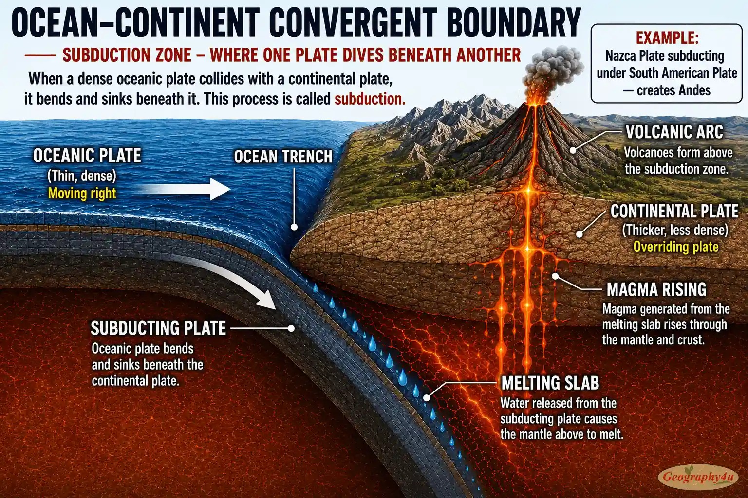
Oceanic-continental convergence: When an oceanic plate meets a continental plate, the denser oceanic plate sinks beneath the continental plate in a process called subduction. The descending plate creates a deep ocean trench at the surface, and as it sinks, it heats up, releases water, and triggers melting in the mantle above. The resulting magma rises through the continental crust and erupts as a chain of volcanoes parallel to the coast.
This is exactly how the Andes Mountains formed: the Nazca Plate (oceanic) is subducting beneath the South American Plate (continental), creating both the Peru-Chile Trench offshore and the volcanic Andes onshore. The same process built the Cascade Range in the western United States, where the Juan de Fuca Plate subducts beneath the North American Plate, producing volcanoes like Mount Rainier, Mount St. Helens, and Mount Hood.
Oceanic-oceanic convergence: When two oceanic plates collide, the older, denser plate subducts beneath the younger one. This creates volcanic island arcs — chains of volcanic islands that form parallel to a deep trench. Japan, the Philippines, the Aleutian Islands, and the Mariana Islands are all examples. The Mariana Trench, formed where the Pacific Plate subducts beneath the Philippine Plate, is the deepest place on Earth at approximately 11,000 meters below sea level.
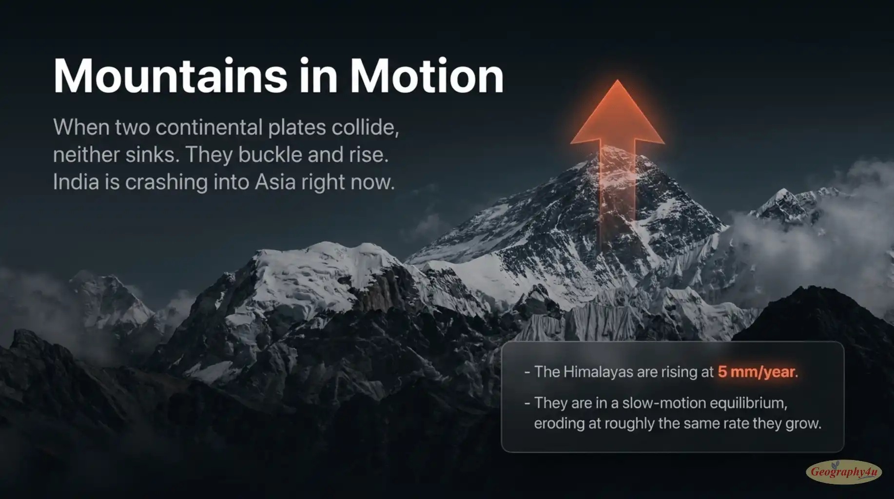
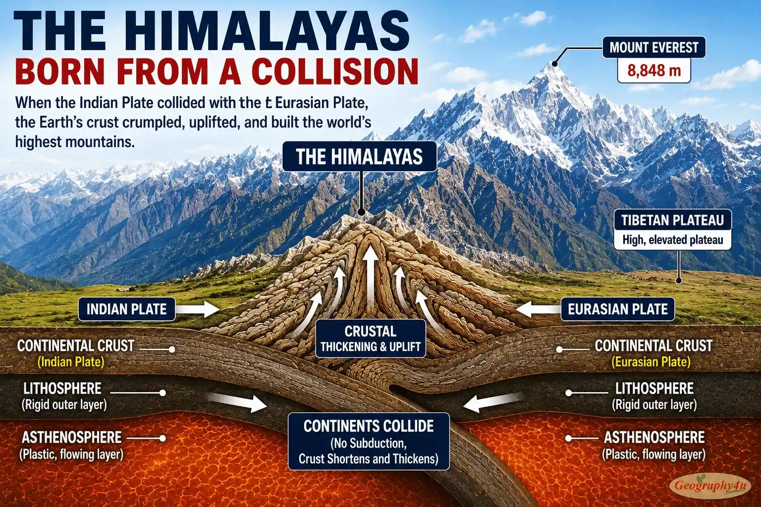
Continental-continental convergence: When two continental plates collide, neither one is dense enough to subduct. Instead, both plates buckle, fold, and pile up — building enormous mountain ranges. The Himalayas are the classic example: about 50 million years ago, the Indo-Australian Plate (carrying India) crashed into the Eurasian Plate. The collision is still happening, and the Himalayas are still rising at roughly 5 mm per year.
3. Transform Boundaries — Where Plates Slide Past Each Other
At transform boundaries, two plates slide horizontally past one another. No new crust is created and no crust is destroyed — but enormous amounts of stress build up along the fault, and that stress is released as earthquakes.
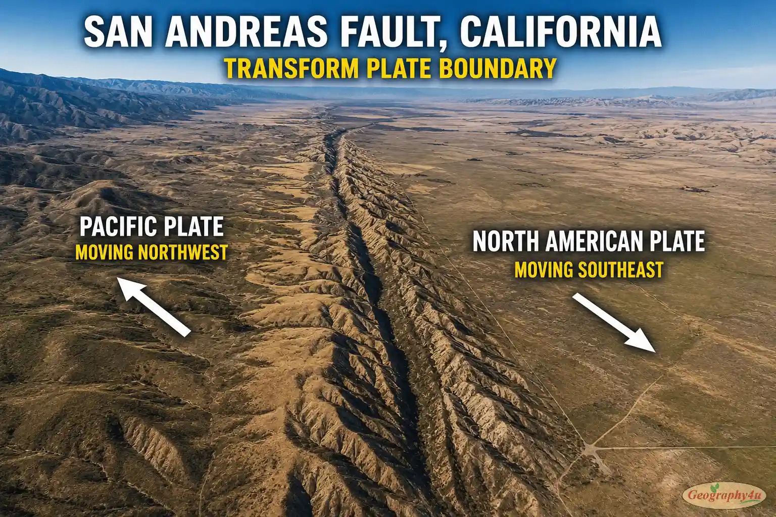
The most famous transform boundary in the world is the San Andreas Fault in California, where the Pacific Plate slides northwest past the North American Plate at about 5 cm per year. GPS measurements show the deep slip rate along the San Andreas itself is about 2 cm per year, with the rest of the motion distributed across nearby parallel faults. The San Andreas extends for about 1,200 km through California and is the source of major earthquakes including the devastating 1906 San Francisco earthquake.
Other significant transform boundaries include the North Anatolian Fault (Turkey), the Alpine Fault (New Zealand), and the Dead Sea Transform (Middle East). All of these are major earthquake zones.
4. Plate Boundary Zones — The Messy Reality
The fourth, less-publicized category is plate boundary zones. In some regions, the boundary between two plates is not a single sharp line but a broad zone of deformation hundreds of kilometers wide. The Mediterranean region, for example, is a complicated mess of small plates and microplates squeezed between the African and Eurasian plates. Western North America from California to Wyoming is another zone, where the simple Pacific-North American boundary spreads its motion across many faults stretching far inland.
What Drives Plate Movement?
For decades, geologists explained plate motion with a single answer: mantle convection. Hot rock rises, cool rock sinks, and the plates ride along on top like leaves on a slow-flowing river. The reality, scientists now know, is more complex. Three forces work together — and one of them, ignored for decades, turns out to be the most important.
Slab Pull — The Dominant Force
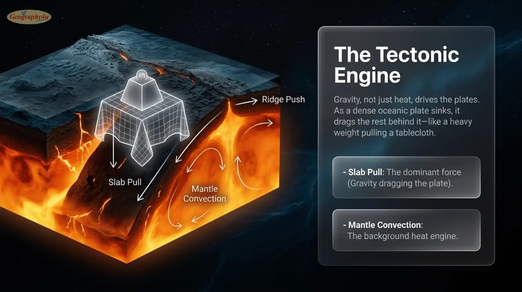
Slab pull is now considered the strongest driver of plate motion. It works like this: at a subduction zone, a heavy oceanic plate sinks into the mantle. As it descends, gravity continues to pull it downward, and the descending slab drags the rest of the plate with it — like a tablecloth being slowly pulled off a table by a heavy weight on the floor.
This is why the fastest-moving plates are always the ones with the largest subduction zones along their edges. The Pacific Plate, with subduction occurring along most of its western and northern boundaries, moves at 7-10 cm per year. The Nazca Plate, almost entirely surrounded by subduction, moves at 7-8 cm per year. The Eurasian Plate, with very little active subduction, moves at only 1-2 cm per year.
Mantle Convection — The Background Engine
Mantle convection still matters — it provides the broader circulation pattern within which plates move and is the ultimate source of heat that allows the system to function. But on its own, mantle convection is probably not strong enough to drive surface plates at the speeds we observe. It works in combination with the other forces, particularly by softening the asthenosphere so plates can slide more easily.
Ridge Push — A Modest Contributor
Ridge push occurs at mid-ocean ridges, where new crust is born hot and elevated. As this fresh crust cools and ages, it becomes denser and slides “downhill” away from the ridge under the force of gravity. This pushing motion contributes to plate movement, but is generally considered a weaker force than slab pull.
How Fast Do Plates Actually Move?
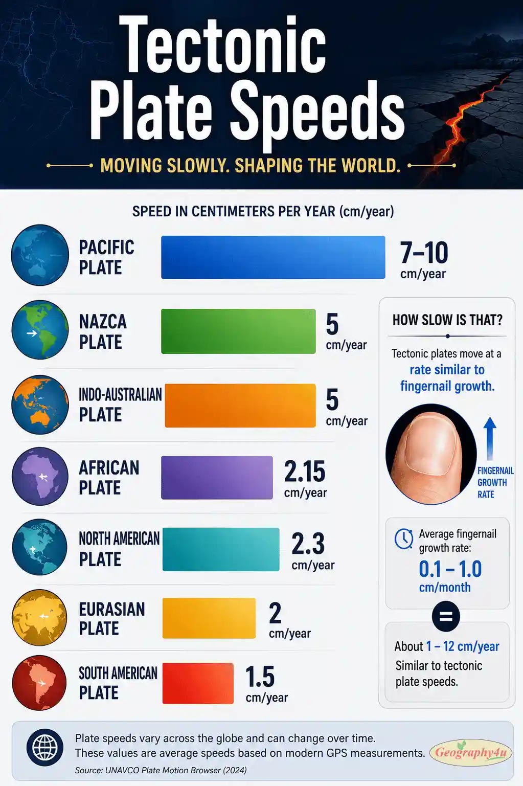
Tectonic plates move at roughly the same rate as your fingernails grow. That comparison, popularized by the United States Geological Survey, is not just a folksy analogy — it is mathematically accurate. Average human fingernail growth is about 3.5 mm per month, or 4 cm per year. The average tectonic plate moves at about 5 cm per year. They really are about the same.
The Speed Range
Different plates move at very different speeds, ranging from 1 to 15 centimeters per year:
- Fastest: The Pacific Plate near the East Pacific Rise, where it moves up to 15 cm per year. Average across the whole plate is 7-10 cm/year.
- Among the fastest: The Nazca Plate (7-8 cm/year), which is currently subducting beneath South America to build the Andes.
- Mid-range: The Indo-Australian Plate at 6-7 cm/year, the African Plate at 2-3 cm/year.
- Slowest: The Eurasian Plate at 1-2 cm/year, and parts of the Antarctic Plate at less than 1 cm/year.
How We Measure Plate Motion
Three modern technologies allow us to measure plate motion with extraordinary precision:
Global Positioning System (GPS): By anchoring permanent GPS receivers in bedrock and measuring their positions over years, scientists can detect movement of less than 1 millimeter per year. A landmark NASA analysis confirmed GPS could track plate velocities with uncertainties as low as 1.2 millimeters per year. Today, dense networks of permanent GPS stations monitor plate boundaries continuously, feeding data into earthquake hazard models and volcanic monitoring systems.
Satellite Laser Ranging (SLR): Lasers fired from ground stations bounce off satellites and return. Precise measurement of the round-trip time reveals tiny changes in distance — and therefore plate movement.
Very Long Baseline Interferometry (VLBI): Networks of radio telescopes observe distant quasars (the most stable reference points known to science). By measuring the tiny differences in arrival times of radio waves at different telescopes, scientists can determine the relative motion of those telescopes — and the plates they sit on.
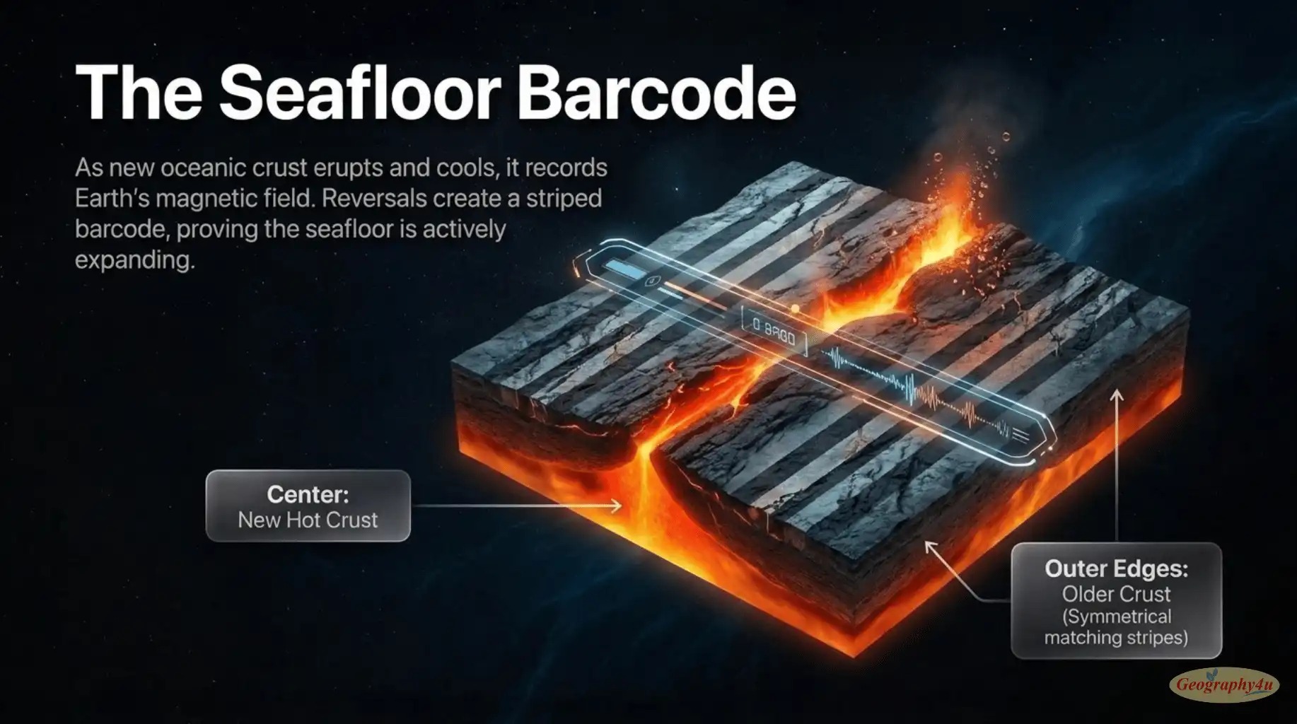
Beyond satellite methods, paleomagnetism — the study of magnetic patterns preserved in oceanic crust — allows scientists to measure plate motion over geological time. As new oceanic crust forms at mid-ocean ridges, it records Earth’s current magnetic polarity. Periodic magnetic reversals create a striped pattern on the seafloor that can be dated to determine historical spreading rates.
The Evidence: How We Know Plate Tectonics Is Real
Plate tectonics is not a guess or a metaphor. It is one of the most thoroughly verified theories in all of science, supported by independent lines of evidence that all converge on the same conclusion. Here are the five key pieces.
1. Continental Fit
The most obvious evidence is the simplest: if you look at a world map, the coastlines of South America and Africa fit together like puzzle pieces. The bulge of Brazil tucks neatly into the Gulf of Guinea. This was first noticed in the 1500s by Flemish cartographer Abraham Ortelius and famously revived by Alfred Wegener in 1912. We now know this fit is not a coincidence — these continents were once joined.
2. Matching Fossils Across Oceans
Identical fossils of plants and animals have been found on continents now separated by thousands of kilometers of ocean. The fossil reptile Mesosaurus — a small freshwater swimmer that could not possibly have crossed an ocean — appears in both South America and Africa in rocks of the same age. The seed fern Glossopteris appears across South America, Africa, India, Australia, and Antarctica. These distributions only make sense if the continents were once joined.
3. Matching Rock Formations and Mountain Belts
The Appalachian Mountains in eastern North America have an identical age, structure, and rock composition as the Caledonian Mountains in Scotland and the Atlas Mountains in Morocco. When you reassemble the continents into Pangaea, these mountain ranges line up into a single continuous belt — exactly as you would expect if they were once part of one mountain system.
4. Magnetic Stripes on the Seafloor
Earth’s magnetic field has reversed direction many times over geologic history (north becomes south, south becomes north). When new oceanic crust forms at a mid-ocean ridge, magnetic minerals in the cooling rock align with whatever direction the field is pointing at that moment. The result is a symmetric pattern of magnetic stripes radiating outward from every mid-ocean ridge — like a barcode of Earth’s magnetic history. This pattern, discovered in the 1960s, was the smoking gun that finally convinced skeptics. Plates are not just moving — they are actively creating new ocean floor in real time.
5. Modern GPS Measurements
The final piece of evidence is direct observation. We can now watch plates move in real time using GPS satellites. Every year, GPS networks confirm that Hawaii is creeping closer to Japan, that California is sliding northwest relative to the rest of North America, and that India is still pushing into Asia. The textbooks predict exactly the speeds and directions we measure. The theory has graduated from inference to observation.
The History of the Theory
Plate tectonics is one of the most successful scientific theories ever formulated, but it took nearly half a century to be accepted. The story is a fascinating example of how science actually works — not as a march of obvious truths, but as a long argument punctuated by occasional revolutions.
1912: Alfred Wegener and Continental Drift
The story begins with German meteorologist Alfred Wegener, who in 1912 published a hypothesis he called continental drift. Wegener proposed that the continents had once been joined in a single supercontinent he named Pangaea (“all earth”), which had broken apart and slowly drifted to its current configuration.
His evidence was compelling: the matching coastlines, the fossil distributions, the identical rock formations across oceans. But Wegener could not explain how continents moved — what force could drag a continent across an ocean? Without a plausible mechanism, his theory was widely rejected, and Wegener was largely dismissed by the geological establishment until his death in 1930 on a Greenland expedition.
1960s: The Revolution
For nearly fifty years, continental drift remained a fringe idea. Then, in the 1960s, three discoveries transformed it into the modern theory of plate tectonics.
In 1960-1962, American geologist Harry Hess proposed sea-floor spreading. Studying the ocean floors mapped during World War II submarine sonar surveys, Hess realized that mid-ocean ridges were sites where new crust was being created and pushed outward. The continents were not plowing through the ocean floor (as Wegener had imagined) — they were riding on top of plates that included the ocean floor itself.
In 1963, British geologists Frederick Vine and Drummond Matthews published the magnetic stripe evidence that confirmed Hess’s hypothesis. The seafloor was unambiguously expanding outward from mid-ocean ridges.
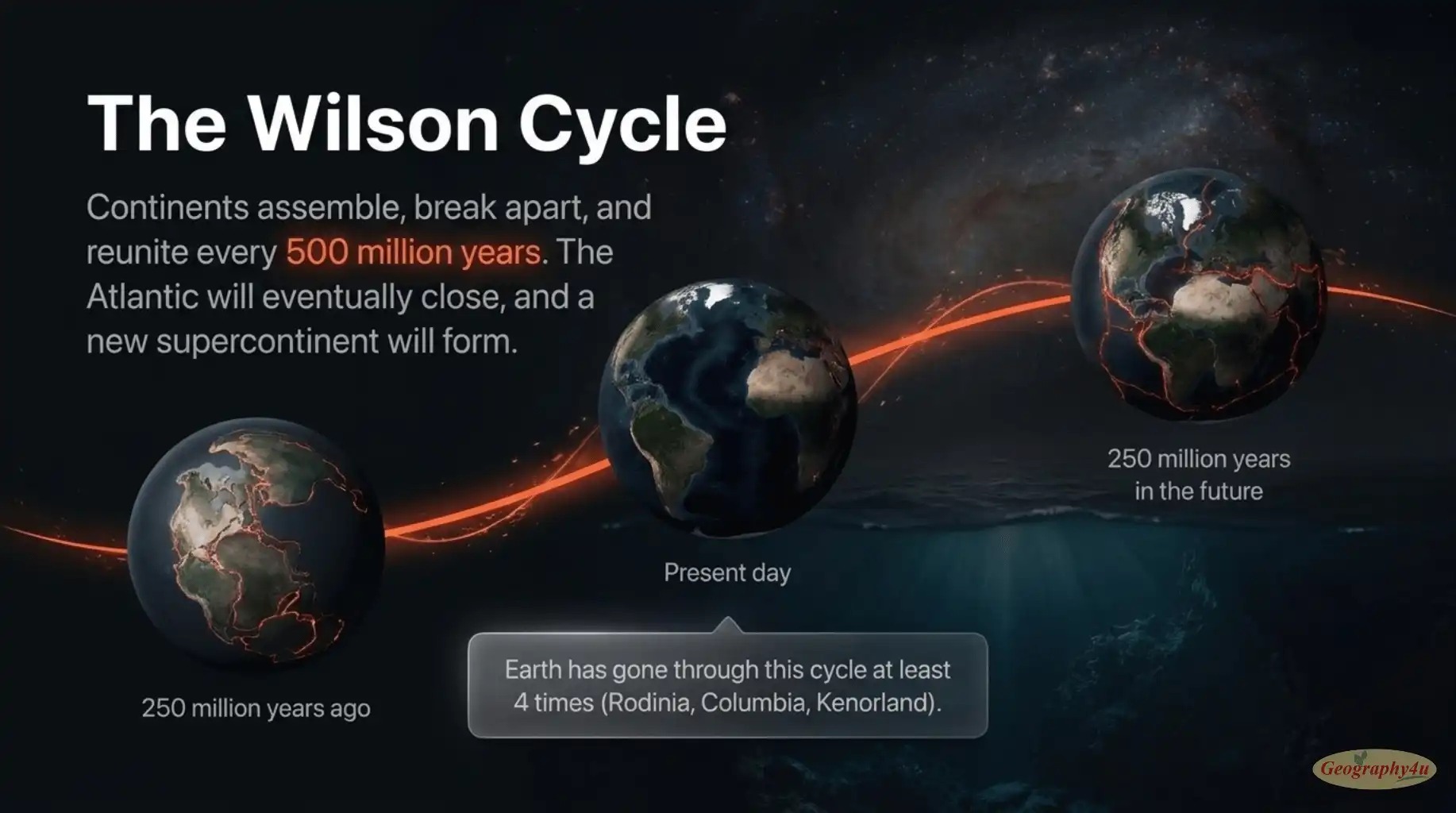
In 1965, Canadian geologist J. Tuzo Wilson connected the final pieces. He identified transform faults as a new class of plate boundary, and proposed the Wilson cycle — the idea that supercontinents repeatedly form and break apart over hundreds of millions of years. Wilson’s work essentially completed the modern theoretical framework.
By 1968, plate tectonics was accepted by virtually all geologists. Wegener — dismissed in his lifetime — was vindicated 38 years after his death. Today, his original 1912 hypothesis is taught in every introductory geology course on Earth.
Real-World Impact: Earthquakes, Volcanoes, Mountains, and Life
Plate tectonics is not just an abstract theory about how continents move. It directly shapes nearly every major feature of our planet — and very probably made life itself possible.
Earthquakes
Approximately 90 percent of all earthquakes occur at plate boundaries. When two plates grind against each other, friction prevents smooth motion. Stress builds up over decades or centuries, locked rocks deform like a bent ruler, and eventually the rock fails — releasing all the accumulated energy as an earthquake.
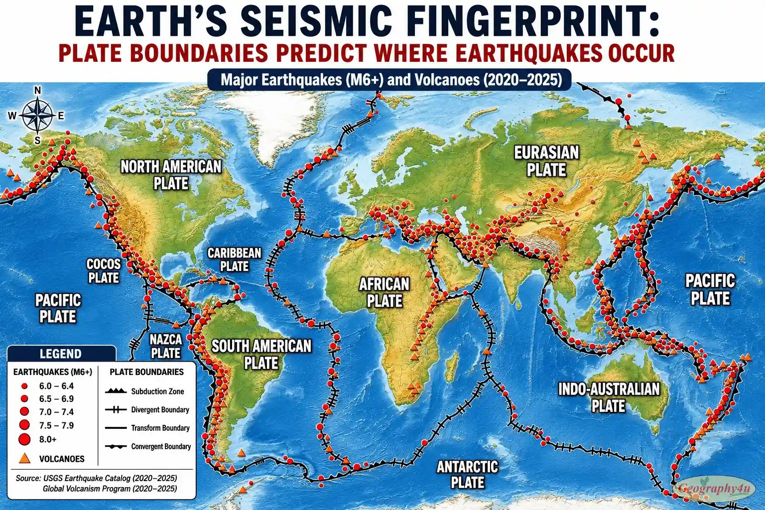
The largest earthquakes happen at convergent boundaries where one plate is subducting beneath another. The 1960 Valdivia earthquake in Chile (magnitude 9.5, the largest ever recorded), the 2011 Tōhoku earthquake in Japan (magnitude 9.1, which triggered the Fukushima disaster), and the 2004 Indian Ocean earthquake (magnitude 9.1, which produced the Boxing Day tsunami) were all subduction zone earthquakes. Transform boundaries like the San Andreas typically produce smaller but still devastating earthquakes — the 1906 San Francisco earthquake was about magnitude 7.9.
Volcanoes
About 75 percent of the world’s active volcanoes are located along plate boundaries, mostly at convergent ones. Subducting oceanic plates carry water down into the hot mantle, lowering the melting temperature of the rock and producing magma that rises to the surface as volcanoes.
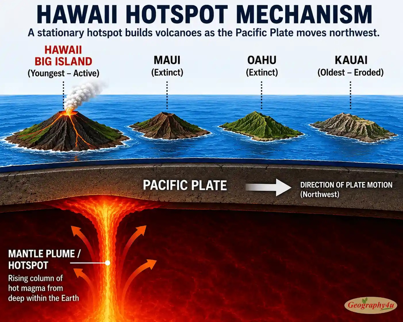
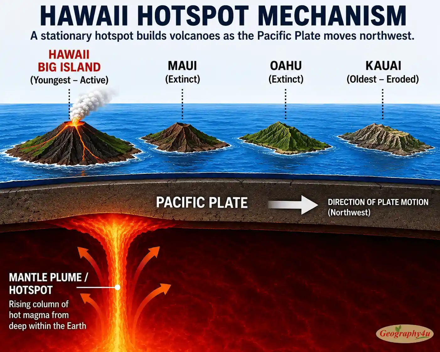
The remaining 25 percent of volcanoes form in two other settings. Some sit directly on divergent boundaries, where mantle rock rises to fill the gap (Iceland is an example). Others occur in the middle of plates, far from any boundary, at hotspots — fixed plumes of unusually hot mantle material rising from deep within Earth. As a plate moves over a hotspot, it produces a chain of volcanoes that gets progressively older away from the active hotspot. The Hawaiian Islands are the textbook example: the Big Island is currently above the hotspot and volcanically active, while older Hawaiian islands to the northwest were active in the past and are now extinct.
Mountain Building
Almost every major mountain range on Earth is the product of plate tectonics. The Himalayas were built by India crashing into Asia. The Andes are still being built by the Nazca Plate sliding beneath South America. The Alps were created by Africa colliding with Europe. The Appalachians and Atlas Mountains are remnants of an ancient collision when Pangaea was assembled. The Rockies were pushed up by complex tectonic events during the assembly of North America.
Even mountains that look “old” are continuously interacting with tectonic processes. Erosion grinds them down, but tectonic uplift pushes them back up. The Himalayas are still rising at about 5 mm per year, even as they erode at roughly the same rate. They are essentially in a slow-motion equilibrium between the forces building them and the forces tearing them down.
Life Itself
This may be the most extraordinary impact of all. Plate tectonics is increasingly understood as essential to life on Earth — and its absence may be why other planets in our solar system are dead.
Plate tectonics drives the long-term carbon cycle. Volcanoes release carbon dioxide from Earth’s interior into the atmosphere. Weathering of fresh rock (created by mountain-building) draws carbon dioxide back out of the atmosphere and locks it into ocean sediments. Subduction then carries those sediments back into the mantle, where the carbon is eventually re-emitted by volcanoes — completing the cycle. This process has acted as a planetary thermostat for billions of years, keeping Earth’s climate stable enough for life.
Plate tectonics also recycles nutrients from the deep ocean back to the surface, distributes mineral resources across continents, and creates the diverse environments — mountains, valleys, coasts, rifts, plains — that have driven biological evolution. Without plate tectonics, Earth would likely be Venus. Same size. Same starting materials. Same distance from a similar star. But Venus has no plate tectonics, and as a result, no carbon cycle, no climate regulation, and a runaway greenhouse atmosphere with surface temperatures of 460 °C.
Pangaea and the Future of Earth’s Continents
The continents have not always been arranged the way they are today. Plate tectonics has rearranged them many times throughout Earth’s history, in a roughly cyclical pattern called the Wilson cycle. Continents come together to form supercontinents, then break apart, drift around the globe, and eventually reassemble into a new supercontinent.
Pangaea — The Most Famous Supercontinent
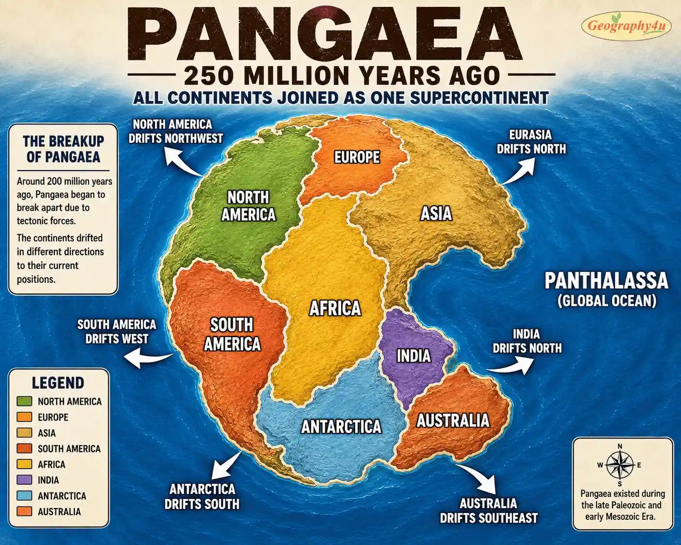
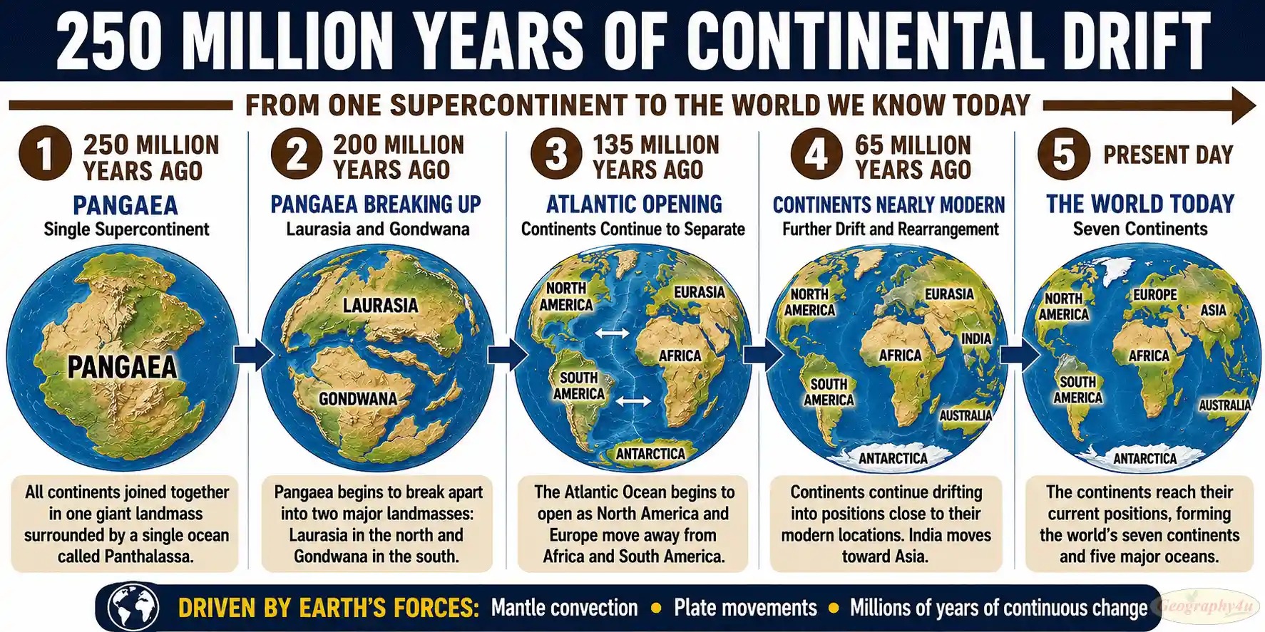
Pangaea existed from about 335 million to 175 million years ago. At its peak, it included virtually all of Earth’s land area as a single C-shaped supercontinent stretching from pole to pole, surrounded by a single global ocean called Panthalassa.
Pangaea began breaking apart about 200 million years ago, splitting first into two large landmasses: Laurasia in the north (which would become North America, Europe, and most of Asia) and Gondwana in the south (which would become South America, Africa, India, Antarctica, and Australia). Over the next 100 million years, these landmasses fragmented further, and the pieces drifted to their current positions.
Earlier Supercontinents
Pangaea was not the first supercontinent — just the most recent one whose evidence we can clearly read. Before Pangaea, geologists have identified earlier supercontinents:
- Rodinia — formed about 1.1 billion years ago, broke up about 750 million years ago.
- Columbia (or Nuna) — formed about 1.8 billion years ago.
- Kenorland — formed about 2.7 billion years ago.
The cycle of assembly and breakup appears to have a periodicity of roughly 400-600 million years. Earth has gone through this cycle at least four or five times.
The Next Supercontinent
Geophysicists predict that the continents will reassemble into a new supercontinent in approximately 200-250 million years. Different models predict different outcomes:
- Pangaea Ultima: The Atlantic Ocean stops widening and begins closing again. The Americas reverse course and slam into Africa and Europe. The result is a new supercontinent that closely resembles Pangaea.
- Amasia: The continents drift northward and converge near the North Pole. Most landmass ends up in a polar configuration.
- Aurica: Both the Atlantic and Pacific oceans close while a new ocean opens in the middle of present-day Asia, creating a supercontinent centered roughly where modern Asia is now.
Which model is correct? Probably none of them, exactly. But the larger pattern is robust: the Wilson cycle continues, the continents will rearrange, and a new supercontinent of some kind is in Earth’s future.
2025-2026 Research: What Scientists Just Discovered
Plate tectonics is a 60-year-old theory, but research is far from finished. Four discoveries published in the last 18 months have added significant new understanding — and they are barely covered in the older articles currently ranking on Google.
The Mantle Anchors Discovery (January 2025)
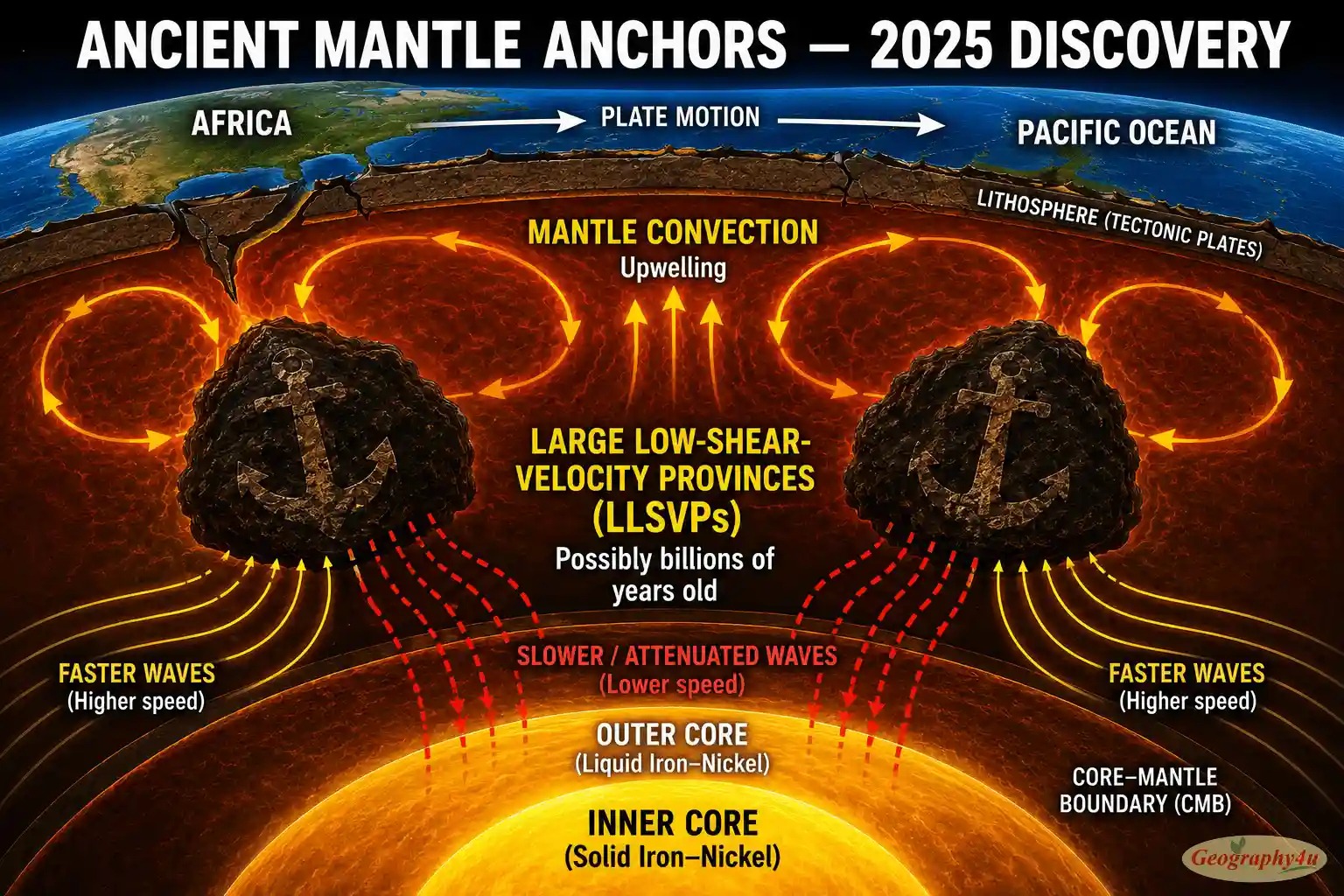
In January 2025, a team led by lead author Sujania Talavera-Soza and senior author Arwen Deuss at Utrecht University published a study in the journal Nature that fundamentally changed how we think about Earth’s deep interior.
The team analyzed how seismic energy dissipates as waves travel through different parts of the mantle — not just how the waves slow down (which had been studied for decades) but how much energy they lose. Their results revealed that beneath Africa and the Pacific Ocean, there are two enormous structures, called Large Low-Shear-Velocity Provinces (LLSVPs), that appear to be remarkably stable. These are not new convection cells; they are ancient features that may have persisted for billions of years.
The implication is profound. Earth’s interior contains long-lived “anchors” that influence volcanic activity, plate tectonics, and mantle convection over immense stretches of geological time. The simple picture of a uniformly stirring mantle is being replaced by a more complex one in which certain regions have been stable for nearly the age of Earth itself.
The Plate Reorganization Tipping Points (September 2025)
In September 2025, researchers Joshua Guerrero and colleagues published a study in Scientific Reports showing that tectonic plate reorganization events — the rare moments when plate motions suddenly and dramatically shift — appear to occur when the system passes a kind of tipping point.
Their numerical models, simulating 144 million years of mantle convection, showed that small changes at subduction locations can cascade into rapid reorganization of the entire plate system. The most recent such reorganization, identified in the famous bend of the Hawaii-Emperor seamount chain, was driven by exactly this kind of subduction-initiation tipping point.
This research has important implications for predicting how Earth’s tectonic system might evolve over the next tens of millions of years, and for understanding the rare but dramatic moments in Earth’s past when continents seemed to suddenly change direction.
Cascadia Is Tearing Itself Apart (October 2025)
For the first time, scientists have caught a subduction zone in the act of dying. Using the 2021 Cascadia Seismic Imaging Experiment (CASIE21) and a 15-kilometer-long array of underwater sensors, researchers led by Brandon Shuck imaged the Juan de Fuca plate — the small oceanic plate sliding beneath the Pacific Northwest — breaking apart piece by piece. The study, published in Science Advances, revealed that the plate is not sinking smoothly. It is fragmenting into microplates as it goes.
“This is the first time we have a clear picture of a subduction zone caught in the act of dying,” Shuck said. The finding may force seismologists to rethink the timing and magnitude of the long-anticipated “Big One” earthquake that the Cascadia Subduction Zone is expected to produce — a magnitude 8-9 event that will affect Seattle, Portland, and Vancouver.
Plate Tectonics Began 3.5 Billion Years Ago (March 2026)
Perhaps the most dramatic finding of all came in March 2026, when a team studying ancient rocks in the East Pilbara Craton of Western Australia found evidence of “relative motion” between geological formations from 3.5 billion years ago. Reported widely in CNN and other major outlets, the data suggests plate-like motion was already occurring during the Archean Eon — when Earth was home only to single-celled microbial life.
Previously, geologists had debated whether plate tectonics began as early as 4 billion years ago or as late as 1 billion years ago. The Pilbara research pushes the timeline much further back than most models predicted. The implication is profound: plate tectonics may have helped create the conditions for life itself by recycling nutrients, regulating atmospheric carbon, and stabilizing climate over billions of years.
The 2026 Earthquakes That Confirmed the Map
The first months of 2026 produced a series of major earthquakes — each one falling exactly where plate tectonics theory predicted earthquakes should occur:
- January 27, 2026 — Mandalay, Myanmar (M7.7): Struck along the Sagaing Fault, the transform boundary where the Indian Plate slides past the Sunda Plate.
- March 11, 2026 — Aomori, Japan (M8.7): The Sanriku earthquake, at the Japan Trench where the Pacific Plate subducts beneath the Okhotsk Plate. Maximum Modified Mercalli Intensity X — extreme shaking.
- March 24, 2026 — Tonga (M7.5): Offshore Vava’u, at the Tonga Trench where the Pacific Plate subducts beneath the Indo-Australian Plate.
None of these locations surprised seismologists. All three sit on plate boundaries that have been recognized as major hazard zones for decades. What plate tectonics theory cannot yet do is predict when an earthquake will strike — only where it is likely to occur.
Related read: 7 Criticisms of Continental Drift Theory by Alfred Wegener
Frequently Asked Questions
What is plate tectonics in simple terms?
Plate tectonics is the scientific theory that Earth’s outer shell is divided into about 15 large rigid pieces called plates, which slowly move on top of a hot, flowing layer underneath. As these plates collide, pull apart, or slide past each other, they build mountains, open oceans, and trigger earthquakes and volcanoes.
How fast do tectonic plates move?
Tectonic plates move at roughly the same rate as human fingernails grow — between 1 and 15 centimeters per year. The Pacific Plate is the fastest, averaging 7-10 cm per year, while the Eurasian Plate is among the slowest at about 1-2 cm per year. GPS satellites can now track this movement to within a fraction of a millimeter.
What are the 7 major tectonic plates?
The seven major tectonic plates are the Pacific Plate, North American Plate, Eurasian Plate, African Plate, Antarctic Plate, Indo-Australian Plate, and South American Plate. Together they cover about 94% of Earth’s surface. There are also seven or eight minor plates and dozens of microplates.
What causes tectonic plates to move?
Tectonic plates move primarily because of three forces: mantle convection (heat rising from the core circulating the molten rock below the crust), slab pull (heavy oceanic plates sinking into the mantle and dragging the rest of the plate with them), and ridge push (new crust forming at mid-ocean ridges and pushing older crust outward). Slab pull is the dominant force for fast-moving plates.
What are the four types of plate boundaries?
There are three main types of plate boundaries — divergent (where plates pull apart, creating new crust), convergent (where plates collide, creating mountains, trenches, or volcanoes), and transform (where plates slide past each other, causing earthquakes). A fourth category, plate boundary zones, describes broad regions where deformation spreads across multiple smaller faults.
Who proposed the theory of plate tectonics?
The modern theory of plate tectonics emerged in the 1960s, building on Alfred Wegener’s 1912 continental drift hypothesis. Key contributions came from Harry Hess (sea-floor spreading, 1962), Frederick Vine and Drummond Matthews (magnetic stripe evidence, 1963), and J. Tuzo Wilson (transform faults and the Wilson cycle, 1965). The theory was widely accepted by the late 1960s.
How does plate tectonics affect daily life?
Plate tectonics shapes nearly every aspect of life on Earth. It determines where earthquakes and volcanic eruptions occur, builds the mountains that capture rain and create rivers, recycles carbon between the atmosphere and Earth’s interior to regulate long-term climate, distributes mineral resources, and even helped create conditions for life itself. Without plate tectonics, Earth would likely be a dead planet like Venus.
Will the continents come back together?
Yes. Geophysicists predict the next supercontinent will form approximately 200-250 million years from now. Different models predict different shapes — Pangaea Ultima has the Atlantic closing, while Amasia has continents converging at the North Pole. The continents have cycled between unified supercontinents and dispersed configurations multiple times over Earth’s history, a pattern called the Wilson cycle.
Final Thoughts: Why Plate Tectonics Matters
Plate tectonics is the closest thing earth science has to a unified theory. It explains why mountains exist, why earthquakes happen where they do, why volcanic eruptions cluster along certain coasts, why fossils of identical reptiles appear on continents now separated by oceans, and why Earth — alone among the planets we have studied — has remained habitable for nearly four billion years.
It is also a reminder of the immense scale of geological time. The continent you live on has been a different shape, in a different location, on a different planet — climatically speaking — many times over. The mountains in the distance are still growing. The ocean off the coast is still widening or narrowing. The ground beneath you is moving, right now, at exactly the speed your fingernails are growing.
None of this is metaphor. All of it is happening. And almost none of it is over.